
Precision agriculture (also called precision farming) is disrupting the traditional farming industry. In fact, according to precision agriculture studies, precision farming technologies have already increased farmers’ production by 4%, reduced fertilizer use by 7%, decreased herbicide applications by 9%, lowered fossil fuel use by 6%, and gained 4% savings in water.
Whether you’re a small-scale farmer looking to optimize your resources or an agricultural professional seeking to enhance productivity and sustainability on a larger scale, precision agriculture can be a great option. Understanding its uses, from farm mapping to crop condition monitoring and beyond, and its benefits is just the beginning of a journey toward harnessing its full power for your farm.
What is precision agriculture or precision farming?
Precision agriculture, also known as site-specific crop management or precision farming, transforms traditional farming into a high-tech operation driven by data and computational power. It involves using navigational technology to gather detailed information about soil conditions, crop status, and weather predictions to make informed farm management decisions.
Precision farming relies on two fundamental technologies: Global Positioning Systems (GPS) and Geographic Information Systems (GIS). These technologies work hand-in-hand to collect and analyze site-specific data. While GPS provides the positioning and tracking information necessary to accurately monitor farm machinery and crop status, GIS enables spatial and geographical data analysis and visualization. Together, they help facilitate decision support for within-field management.
However, to tap into the full potential of precision agriculture, farmers need more than just GPS; they need the precision of Real-Time Kinematic (RTK) corrections. RTK enhances GPS data by correcting signal distortions and providing centimeter-level accuracy. This level of detail is crucial for tasks requiring high precision, such as seed placement, fertilizer application, and creating detailed farm maps.
Without RTK, managing farms to meet modern needs can be laborious, costly, and imprecise. Most farmers need an accuracy of less than 10 centimeters to achieve accurate mapping. This often leads them to two options: installing a ground-based base station, which involves significant setup and an upfront cost of $4,000, or legacy RTK networks with prohibitive costs of almost $500 per month per drone.
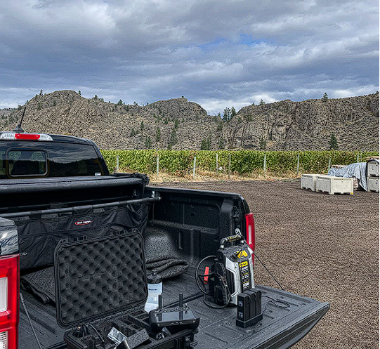
With RTK from Point One Polaris, farmers get affordable and highly accurate RTK–even in remote areas. For many farmers, introducing drones equipped with RTK technology streamlines processes that once took days into a single flight, reducing inspection time to 30 minutes. This not only saves time and money but it also means more precise data collection.
Why do farmers need precision agriculture?
Traditionally, managing a farm involves a lot of guesswork and manual labor. In the past, workers had to trek miles on foot across their fields to collect data about their farms, a costly and inefficient method.
This outdated approach to monitoring and managing fields is not just expensive; it’s also imprecise. In contrast, precision agriculture offers a smarter, more efficient way to understand and respond to the needs of each plot of land.
With precision agriculture, farmers have the power to oversee and manage their fields remotely. Even small-scale farm owners can efficiently manage large tracts of land or multiple small plots without stepping foot on them. This technological leap forward not only enhances the efficiency of crop management but also brings about significant cost savings–all while boosting production.
Precision agriculture is also crucial in optimizing soil use and preserving its quality for future generations. This ensures a stable and sustainable food supply, which is crucial in addressing the global hunger challenge. By making each plot of land as productive as possible without degrading its health, precision agriculture is a beacon of hope for feeding the world’s growing population.
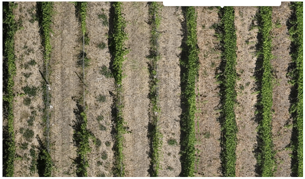
Take, for example, the process of vineyard inspection. Farmers can inspect crops for disease prevention and plant health using drone-based photogrammetry. By photographing entire fields with the RTK network from Point One, experts in winery technology and vineyard management can stitch those photos together for highly detailed maps. With the help of AI-based image recognition software, winemakers can identify common diseases like powdery mildew and pinpoint the specific vines affected for precise treatment.
Precision agriculture technology
The dawn of precision agriculture is akin to the agricultural revolution sparked by the John Deere steel plow in the 19th century. However, the technologies underpinning precision farming are far more advanced and computational, involving a suite of engineering marvels that transcend traditional farming.
Here are the key components that make up the technological backbone of precision agriculture:
GPS Receivers
The journey into precision agriculture begins with GPS receivers. This ground-based technology does more than just pinpoint locations—it serves as the eyes of the farm, gathering real-time data that informs every decision support system.
GPS technology is indispensable, from guiding tractors to exact locations in the field to monitoring crop health and soil conditions.
RTK Networks
Real-time kinematic networks are at the heart of precision agriculture’s unmatched accuracy. These networks provide real-time GNSS corrections, offering centimeter-level accuracy for everything from planting seeds to mapping out irrigation systems.
Unlike traditional methods that require extensive processing to create a coherent map, RTK networks use precise location data as a reference point, significantly reducing processing time and increasing efficiency.
With its network of accurately placed base stations, Point One Polaris exemplifies the best in RTK technology, providing farmers with detailed and reliable farm maps that serve as a foundation for all subsequent agricultural activities. With a low cost of just $50 per month, Polaris RTK is both affordable and highly accurate. It’s available across the United States, Canada, Western Europe, and Australia–and you can try it for free.
Geographic Information Systems
Geographic Information Systems (GIS) play a pivotal role in precision agriculture by processing and visualizing spatial and geographical data. This technology enables farmers to segment their farms into zones based on unique characteristics such as soil type, moisture content, and pest presence.
GIS supports a variety of applications, from viewing historical soil survey maps to analyzing satellite images for environmental changes, making it an invaluable tool for sustainable farm management.
Aerial Technology
Aerial technology has revolutionized crop management by allowing farmers to observe their fields from above, reducing the need for physical scouting. Unmanned Aerial Vehicles (UAVs), or drones, equipped for precision agriculture can perform detailed soil analyses using multispectral, thermal, and hyperspectral imaging.
This saves time and resources and provides a more comprehensive view of field conditions, leading to more informed decision-making and sustainable practices.
Remote Sensors
Remote sensors are the pulse of precision agriculture, offering real-time insights into crop health and soil conditions. Using satellite imagery or drone-collected data, these sensors enable farmers to pinpoint areas of stress or growth within their fields.
The high spectral resolution of modern precision agriculture satellite imagery means that the data collected is incredibly detailed and accurate, offering once unimaginable precision.
Data Analysis
The backbone of precision agriculture is its ability to turn vast amounts of data into actionable insights. Data analysis in precision farming involves synthesizing information from GPS, drones, and satellites to make informed decisions about crop status, weather forecasts, and more. Unlike traditional farming, precision agriculture allows for managing fields as a collection of unique parts, each requiring tailored care.
This granular approach to farm management is made possible through computational analyses, which provide farmers with the insights needed to optimize every aspect of their operations.
VRT Technology
Variable Rate Technology (VRT) represents the earliest and most common application of precision agriculture. VRT enables the precise application of inputs like seeds, fertilizer, and water, based on overlapping data sources such as soil maps and harvest yield data.
This precision farming technology allows for unprecedented efficiency in resource use, further cementing precision agriculture’s role in promoting sustainable, productive, and environmentally responsible farming practices.
Precision Agriculture Examples
Farmers today increasingly turn to precision agriculture to inform their decision support systems, utilizing real-time and site-specific data to make informed choices. This approach allows for a level of management and optimization previously unattainable, affecting every aspect of the farming process. Here are some real-world applications showcasing how precision farming is revolutionizing the industry.
Soil Sampling & Mapping
One of the most critical steps in precision agriculture is soil sampling and mapping. By analyzing site-specific soil data, farmers can understand variations in soil types and moisture levels across their fields. This knowledge enables them to place the exact amount of seed and fertilizer needed to optimize production, enhancing both productivity and sustainability.
Fertilizer
Precision agriculture takes fertilizer application to the next level. Instead of blanket applications, farmers can now apply variable-rate fertilizer treatments. This site-specific approach, allows for adjustments down to the square meter or even square centimeter, ensuring that each plant receives the optimal nutrient amount, reducing waste and environmental impact.
Of course, you need an RTK system that can pinpoint locations down to the centimeter for the most accuracy.
Irrigation
Precision agriculture also transforms irrigation practices through the use of micro-irrigation systems. These systems enable farmers to plan their field irrigation with unprecedented accuracy, identifying areas of high or low soil moisture. Implementing variable-rate irrigation (VRI) technology allows for adjusting the water supply volume to different field parts as needed, greatly improving water use efficiency and contributing to sustainability efforts.
Scouting
Combining scouting with satellite remote sensing is a powerful strategy in precision agriculture. This combination allows growers to detect deviations from normal crop conditions more accurately and efficiently.
Satellite imagery assists in planning plant treatments and selecting agricultural chemicals, making crop management more precise and reducing unnecessary chemical use.
Harvesting
By integrating RTK-enabled GPS and satellite remote sensing, farmers can generate detailed yield maps that reflect various environmental conditions–such as landscape, soil, and weather–to significantly enhance the efficiency and safety of the harvesting operation itself.
This technology is critical for deploying both autonomous and semi-autonomous farm robots, transitioning harvesting from a manual task into a high-tech operation that ensures robots navigate crop rows accurately without causing damage. If you had GPS without RTK, you could be meters off–while RTK-enabled farm robots can harvest with cm-accuracy.
Post-Harvesting
After the harvest, the work doesn’t stop. Monitoring soil quality is a priority to ensure that the natural resources are not depleted. Precision agriculture technologies play a crucial role here, helping to ensure that the soil remains healthy and productive for future crops. This ongoing analysis supports sustainability by ensuring that agricultural practices do not harm the long-term viability of the land.
Crop Condition Monitoring
Geospatial technology, especially drone-based photogrammetry, is also transforming crop condition monitoring. It significantly streamlines the farm management process by enabling detailed inspections for plant health and disease prevention with unmatched precision. This allows for more efficient crop surveillance, which traditionally requires extensive labor and time. For instance, in vineyard applications, the technology enables accurate mapping of individual vines to within 10 centimeters, a level of precision that significantly enhances disease detection and management strategies.
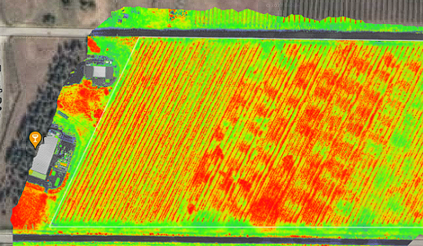
Affordable RTK solutions like Point One’s Polaris have made this high level of accuracy more accessible by overcoming the cost barriers associated with traditional ground-based stations or expensive legacy RTK networks. Using detailed orthomosaic and vegetation index photos for comprehensive scans of the land, farmers can identify specific diseases, such as powdery mildew, directly at the affected crops.
This allows for targeted treatments, improving the efficiency and effectiveness of interventions. Additionally, RTK-enabled GPS helps optimize irrigation by identifying less healthy areas for further investigation.
Precision Agriculture Pros and Cons
Precision agriculture represents a leap forward in the way we approach farming, integrating technologies and data analysis to create a more efficient, sustainable, and productive agricultural system.
However, like any significant evolution, it comes with its set of challenges and considerations.
Benefits of precision agriculture
Precision agriculture offers numerous benefits, transforming the agricultural landscape in ways that support both the farmer and the environment. Here’s a look at some of the key advantages:
- Cost-savings: One of the primary benefits is the reduction in the cost of materials and resources like water, seeds, and fuel. By applying site-specific management practices, precision agriculture ensures that resources are used optimally, minimizing waste and maximizing efficiency.
- Soil health: Maintaining the health of the soil is crucial for sustainable agriculture. Precision farming reduces the need for pesticides and excessive fertilizer use, thereby preserving soil quality and promoting a healthier ecosystem.
- Control: Precision agriculture reduces the farm’s dependence on weather conditions, allowing farmers to make more informed decisions based on real-time data. This level of control can lead to more stable production outcomes and less risk of crop failure due to adverse weather.
- Maximizing potential: By optimizing the conditions for crop growth, precision agriculture helps in realizing the genetic potential of the crops produced. This leads to higher yields and better-quality produce.
- Sustainability: This approach uses resources only to the extent necessary to address specific issues, significantly reducing the environmental footprint of farming. It promotes nutrient balance and reduces the development of pesticide resistance, contributing to more sustainable agricultural practices.
Cons of precision agriculture
Despite its many benefits, precision agriculture can present some challenges:
- Weather dependency: While precision agriculture can mitigate some effects of adverse weather, it does not eliminate the inherent risk of farming being dependent on weather conditions. However, this is the case for most farming practices, not just those that rely on precision agriculture. Despite technological advancements, farmers must still navigate the challenges of unpredictable weather patterns. The key difference is that precision agriculture equips them with better tools and data to make informed decisions, potentially reducing the impact of weather-related risks on their crops and livestock.
- Security: With the increased use of digital technologies in precision agriculture, cybersecurity has become a critical concern. The risk of data theft or tampering can have serious implications, making data protection and system security paramount. Choosing a secure RTK system like Point One is crucial for protecting sensitive location data against cybersecurity threats. Point One ensures the utmost security through encryption, real-time monitoring, and defenses against signal spoofing and jamming, keeping your agricultural data safe and secure.
- Accuracy: Accuracy in farming operations is critical, and standard GPS alone often falls short of the precision required. However, by integrating RTK technology, farmers achieve the high level of accuracy necessary for optimal results in precision farming.
Optimize Your Precision Agriculture for Sustainable Farming
By embracing precision farming, farmers can step into a future where farming is not only more efficient and productive but also more sustainable and in harmony with the environment.
Today, precision agriculture represents a significant opportunity for farmers to refine their operations, enhance efficiency, and promote sustainability. With the right approach and the support of industry leaders like Point One Navigation, you can optimize your precision agriculture practices for sustainable farming success.
Contact a specialist to discover how the Polaris RTK network and precision technologies can transform your farm mapping and agricultural practices today.