
RTK, or Real-Time Kinematic positioning, is a highly specialized technique that is revolutionizing geospatial positioning. Applications that depend on precise positioning, from land surveying to advanced robotics, are benefitting from RTK and the unprecedented accuracy in real-time location data that the technology offers.
This article explains what RTK is, how it works, what the benefits are, and how it is being used in today’s world. If you’re considering RTK for your own business or are just a geospatial technology enthusiast, let this article from Point One Navigation guide you through everything you need to know.
What is RTK (Real-time Kinematic) Technology?
RTK positioning corrects errors in standard satellite data to achieve exceptionally precise positioning data. It’s accessible in a few different ways. While building your own RTK system might seem like an exciting challenge–especially for the DIY-driven–concerns such as accuracy, maintenance, and costly downtime often pose greater risks than rewards. And free RTK or NTRIP providers, while tempting, aren’t always reliable.
Ultimately, the most dependable and easiest method is to access a professional RTK network like Polaris by Point One Navigation. If you can go to a site, pull out your survey stick, and get to work, you’ll be much more productive than if you had to set up and manage base stations on your own.
With Point One, you can set up in 5 minutes by connecting to a single NTRIP mount point. After that, you access high-precision GNSS accuracy from 10cm to 1cm–at lightning-fast convergence times of less than five seconds. And, this is all at an affordable price point of just $60 per month.
How RTK Works
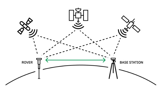
RTK base and rover set up.
RTK positioning technology relies on communication between the user’s rover and the RTK provider’s base station. The base station is surveyed very precisely so that its position is known to within one or two centimeters.
It then transmits its observations to the rover receiver in real time. By comparing the measurements the rover receiver makes to those obtained from the base station, the rover is able to cancel out all the major sources of error in its own measurements. The resulting measurements are 100x more precise than normal stand-alone measurements.
Fixed Base Stations
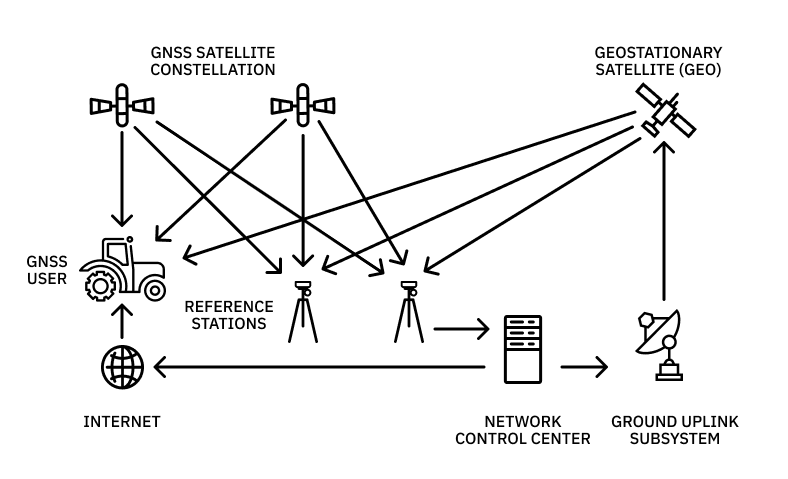
In order to correct errors in satellite signal data, RTK positioning requires stationary sites with known, precise locations to serve as reference points. These are called fixed base stations, which send observations to the rover in real time.
It’s important not to think of RTK base stations as standalone units, but rather as pieces of broader, interconnected networks that together offer more expansive coverage. For example, Point One’s Polaris RTK network has global coverage across the US, EU, UK, CA, and AU and boasts the highest overall density of US RTK corrections networks.
This allows the network to offer scalable solutions and ensure high accuracy, even in areas without cellular coverage or in challenging environments in urban canyons.
RTK Corrections
RTK corrections account for various ambiguities present in navigation constellation signals, which can stem from sources such as satellite orbital errors and atmospheric disturbances. By sharing correctional data in real time, the fixed base station and rover together improve positional accuracy from meter-level to centimeter-level.
Let’s get a little more technical:
- Standalone GNSS positioning relies mostly on very accurate, but not very precise, pseudorange measurements of code phase. RTK relies on extremely precise, but ambiguous, RF carrier phase measurements.
- The heart of RTK is integer carrier phase ambiguity resolution. This process turns the ambiguous carrier phase measurements into highly precise measurements of pseudorange, which can be about 100x more precise than the code phase pseudorange measurements. But, they’re ambiguous to within an integer number of radio carrier wave cycles.
- An RTK-enabled receiver is equipped with a very heavy math routine that’s able to resolve the ambiguities in the carrier measurements. This unlocks the use of the previously unusable carrier phase and enables position determination to within a couple centimeters.
Fortunately, when using an RTK service like Point One Polaris, you don’t have to worry about any of these details. You can get set up in five minutes by connecting to a single NTRIP mount point–and then access cm-accurate positioning lighting-fast convergence times.
A Comparison of RTK Terms
Understanding how RTK combines and contrasts with existing positioning systems illustrates how this technique is revolutionizing the capabilities of standard satellite data.
RTK vs GPS
RTK improves the accuracy of standard Global Positioning System (GPS) data from meter-level to centimeter-level. While GPS systems help provide location information typically correct within a few meters and is perfectly suitable for some applications, it’s not accurate enough for fields that require high positional precision like surveying, robotics, and autonomous vehicles.
RTK-enabled GPS achieves centimeter-level accuracy by using a fixed base station to correct errors in real-time.
RTK vs GNSS positioning
While GPS constitutes a specific constellation within the GNSS framework, RTK can also be used to correct data sourced from other Global Navigation Satellite Systems (GNSS) such as GLONASS, Galileo, and BeiDou. Several factors make standard GNSS signals prone to error, including ephemeris inaccuracies, satellite clock inconsistencies, ionospheric delay, and tropospheric disturbances.
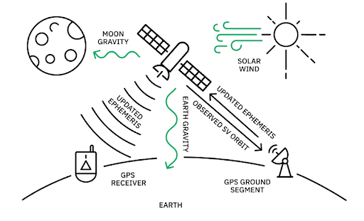
Ephemeris inaccuracies can cause errors in GNSS signals and must be addressed for precise positioning.
RTK accounts for these errors in real-time, continuously broadcasting correction information from the fixed base station to rovers. The rapid calibration enabled by RTK transforms GNSS positioning from an approximate technology to a precise and dependable one.
RTK vs PPP
PPP taps into a limited number of highly precise and accurate stations for signal correction.
Precise Point Positioning (PPP) is another method used to enhance satellite positioning data. While it offers exceptional accuracy, it is not instantaneous like RTK due to its limited number of stations.
PPP takes a long time to converge because the user equipment must estimate models of a weakly observable error on-board the user device. Convergence time is rarely faster than 20 minutes–and may be up to an hour or more.
Single-frequency RTK vs Dual-frequency RTK
Single and dual-frequency RTK are the most common RTK configurations. As the name suggests, single-frequency RTK utilizes one frequency band from satellite signals, providing centimeter-level accuracy when combined with a fixed base station.
Dual-frequency RTK utilizes two frequency bands. The main benefit of multi-frequency is that it makes it easier to observe the values of the integer carrier phase ambiguities which are at the heart of RTK. By providing more than one independent measurement per satellite, it makes it easier for the user equipment to compute an RTK fix. This allows for increased availability and applications across a wide range of conditions.
Benefits of RTK
Now that we’ve broken down how the technology works, let’s take a look at the three unique benefits of RTK that are redefining the capabilities of geospatial positioning.
Positional Accuracy
Without RTK, standard GNSS data is limited in precision due to inherent ambiguities in satellite data. By supplying additional data points, RTK takes satellite data from meter-level accuracy to remarkable centimeter-level precision.
Real-time Corrections
RTK sets itself apart from other satellite correction technologies by its convergence speed. RTK can converge in as little as about one second or just several seconds in more challenging environments. PPP takes multiple minutes–at best.
For applications that require immediate and precise location information, such as autonomous vehicle navigation, the real-time signal calibration afforded by RTK is a must-have.
Reliability
Technology that works occasionally, or only under specific circumstances, is frustrating to adopt and difficult to scale. Known for its reliability, RTK consistently achieves high accuracy under varied conditions. This is a benefit especially attractive to businesses across agriculture, construction, and surveying.
Polaris by Point One offers exceptional reliability, with 99.99% uptime and secure authentication and transport methods to enhance the dependability of corrections data. Reliability is a costly concern for many home-built systems and free NTRIP services that don’t utilize data from the same dense global network of stations.
When it comes to uptimes, only a professional RTK network such as Polaris will provide the most consistently reliable user-experience.
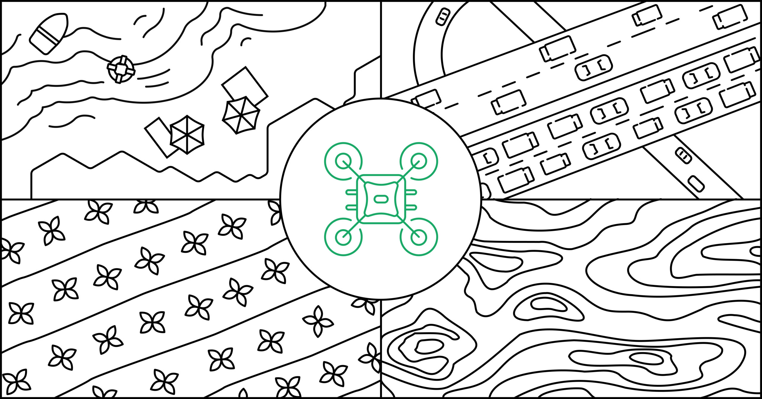
What is RTK Used for?
Where is centimeter-level positional precision making a tangible impact? A range of industries that rely on accurate and real-time geospatial data are benefiting from the new capabilities unlocked by RTK.
Precision Agriculture
RTK enables farmers to precisely control agricultural machinery, such as tractors and harvesters, for tasks like planting, spraying, and harvesting. Elevated precision optimizes field operations, including precise application of fertilizers, pesticides, and irrigation, leading to better crop yields, cost savings, and less harm to the environment.
RTK positioning can also help farmers create detailed field maps and collect more accurate data, aiding in decision-making and resource management.
Robotics
In robotics, precise localization and navigation allow robots to accurately determine their positioning. Centimeter-level precision is critical to various robotic applications, including unmanned aerial vehicles (UAVs) and robotic manipulators, where tasks such as mapping, surveillance, and inspection must be carried out accurately and instantly.
RTK positioning allows robots to navigate complex environments with greater accuracy, efficiency, and safety, enhancing their overall performance and capabilities.
Damage Prevention
Damage prevention is necessary across various industries such as construction, mining, and infrastructure maintenance. RTK enables equipment operators and workers to precisely locate underground utilities, structures, and other sensitive assets in real time.
This helps prevent accidental damage during excavation, drilling, and other ground-disturbing activities, reducing the risk of utility strikes, environmental damage, and costly repairs. RTK positioning can also integrate with geographic information systems (GIS) and asset management software to create detailed maps and records of underground infrastructure, improving planning, maintenance, and emergency response efforts.
Autonomous Vehicles
Autonomous vehicles require precise and instantaneous positioning data for safety, navigation, and control. RTK enables these vehicles to determine their location relative to their surroundings in real time with centimeter-level accuracy.
This level of precision is crucial for ensuring the safety and efficiency of the vehicle, particularly in dynamic environments such as busy city streets or construction sites. When environments become unexpectedly chaotic or lose control, accurate positioning is essential for making split-second decisions and maintaining safe distances from other objects.
Delivery Logistics
In the field of delivery logistics, RTK optimizes route planning, improves efficiency, and ensures accurate delivery tracking. The technology empowers vehicles to efficiently navigate urban environments, find current optimal routes, and avoid traffic congestion.
RTK facilitates real-time tracking of delivery vehicles and packages, enabling logistics companies to monitor delivery progress, estimate arrival times with high accuracy, and provide customers with timely updates.
Construction
On construction sites, RTK is used extensively for precise positioning and control of heavy machinery, such as bulldozers, excavators, and graders. Enabling these pieces of equipment to precisely follow design plans and grades helps minimize rework, reduce material waste, and optimize construction timelines.
Additionally, RTK positioning facilitates real-time monitoring of construction progress and enables accurate as-built documentation, improving project management and quality control on construction sites.
Access the Best RTK Network
Across industries, RTK is taking accuracy and operational efficiency to new heights. From optimizing farming practices to supercharging delivery logistics, RTK is enabling companies to execute more efficiently and better serve their customers.
Interested in learning more about how RTK can meet your specific needs? The experts at Point One Navigation are ready to help. Through best-in-class RTK solutions and services, Point One can show you new solutions to complex challenges and bring the transformative power of RTK to your fingertips. You’ll need just five minutes to set up a single mount point for access to Polaris’s global correction data. Get cm-accurate GNSS positioning with rapid convergence times and enjoy the benefits of professional-grade troubleshooting support and secure, encrypted implementation.
Skip the hassle and known drawbacks of DIY setups and free providers who can’t guarantee reliability. Take advantage of unparalleled GNSS accuracy and operate confidently with our team of experts by your side.