
As once inconceivable technologies like self-driving cars become a reality, Inertial Navigation Systems (INS) are becoming increasingly essential and indispensable. INS helps vehicles and devices know their position, direction, and speed without needing external signals like those from GPS. This makes them incredibly useful in places where GPS can’t reach or isn’t reliable.
The growing importance of INS is particularly evident in the field of autonomous vehicles. As of 2021, about 80 companies were testing roughly 1,400 self-driving cars, trucks, and other vehicles in 36 states across the United States. This significant development in the automotive industry underscores the need for robust and reliable navigation systems like INS, especially as we inch closer to a future dominated by autonomous transportation.
This article from Point One Navigation will explain everything you need to know about INS. We’ll cover what it is, how it works, and why it’s a game-changer for many industries.
What is an Inertial Navigation System (INS)?

An Inertial Navigation System is a navigation technology that calculates an object’s position, velocity, and orientation without needing external references. It does this by measuring the accelerations and rotations applied to the system.
Once an INS knows its starting location, it can track its current location by continuously updating its position based on those measurements.
INS vs GPS
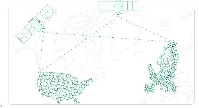
GPS (Global Positioning System) is a satellite-based navigation system that provides location and time information in all weather conditions, anywhere on or near the Earth. It’s an integral part of GNSS (Global Navigation Satellite Systems), a broader term encompassing various satellite navigation systems.
An example of absolute navigation, which refers to determining an object’s position relative to a fixed point or coordinate system, GPS relies on signals from satellites to determine location, which means it needs a clear line of sight for these satellites to work effectively.
In contrast, INS is self-contained – a form of relative navigation. It doesn’t depend on external signals but rather determines an object’s position in relation to its starting location or its position at a previous point in time. This makes it more reliable in places where GPS signals are weak or blocked, like tunnels or dense urban areas.
However, INS systems have their limitations. Over time, small errors in acceleration and rotation measurements can add up, leading to a drift in the calculated position. To counter this, many commercial INS systems are combined with a GNSS receiver (like GPS) for calibration and to improve overall accuracy.
This combination allows the system to leverage the strengths of both technologies – the independence of INS and the accuracy of GPS. Then, integrating an NTRIP system (Networked Transport of RTCM via Internet Protocol) within that setup can introduce additional benefits.
By providing highly accurate GNSS data, NTRIP service providers help reduce the drift of the INS. This integration ensures the INS maintains its accuracy over longer periods and in challenging environments where GNSS signals might be weak or obstructed.
How Does an INS Work?
The core component of an INS is the Inertial Measurement Unit (IMU), which consists of gyroscopes, accelerometers, and sometimes magnetometers or GNSS receivers.
IMU
The IMU (Inertial Measurement Unit) is the heart of an INS. It’s a self-contained system that collects raw sensor data to calculate the position, orientation, and velocity of the object it’s attached to.
The IMU’s primary function is to detect changes in motion and orientation. It does this through a combination of gyroscopes, accelerometers, and, optionally, magnetometers or GNSS sensors.
Gyroscopes
Gyroscopes in an INS measure the rate of rotation around the object’s axis. This helps in determining the orientation or angular velocity of the object. Modern IMUs often use MEMS (Micro-Electro-Mechanical Systems) gyroscopes.
These devices can detect changes in orientation by measuring the Coriolis effect on vibrating elements within the gyroscopes.
Accelerometers
Accelerometers measure the acceleration forces acting on the object, whether speeding up, slowing down, or changing direction. By integrating the acceleration data over time, the INS can calculate velocity and displacements.
This process, known as dead reckoning, allows the INS to track the object’s position relative to a known starting point.
Magnetometers or GNSS Sensors
While not always included, magnetometers can be part of an IMU, providing additional data about the object’s orientation relative to the Earth’s magnetic field. Magnetometers are useful in determining heading information, which, when combined with gyroscopes and accelerometers, can offer more comprehensive orientation data.
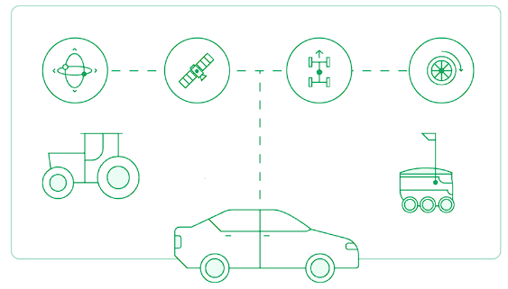
Most commercial INS systems also incorporate GNSS sensors to enhance accuracy. GNSS, such as GPS, provides absolute position information, which can be used to correct or validate the position and velocity estimates obtained from the IMU. This combination is known as sensor fusion.
GNSS Receiver
One of the main challenges with INS is the error accumulation or drift over time, primarily due to small inaccuracies in the measurements of accelerometers and gyroscopes. A GNSS receiver, such as GPS, GLONASS, or Galileo, provides absolute positioning information. When integrated with INS, the GNSS data can correct and calibrate the INS outputs, reducing the drift and enhancing overall accuracy.
Although INS can operate in environments where GNSS signals are weak or blocked (underwater, indoors, or in urban canyons) when the GNSS signal is available, it provides a reliable external reference to ensure the INS’s accuracy. This integration ensures the navigation system remains functional and accurate in challenging environments, switching seamlessly between GNSS-aided and GNSS-denied models.
The combined INS/GNSS system is vital in applications where precision and reliability are crucial, such as autonomous vehicles, aircraft navigation, and maritime navigation. In these applications, even small errors can have significant consequences, so the improved accuracy and reliability of the combined systems are essential.
When integrating GNSS receivers with INS, the decision to use existing systems or build your own, such as an RTK system, can be complex. Ultimately, a professional RTK service provider like Point One Navigation can help mitigate any issues that may arise when combining INS and GNSS.
INS Calculations
Inertial Navigation Systems perform complex calculations to determine an object’s position, velocity, orientation, and altitude. These calculations are fundamental to the system’s ability to provide accurate navigation information.
Attitude
INS calculates altitude by integrating acceleration data along the vertical axis, measured by the accelerometers. This integration involves calculating the change in velocity over time and then integrating this velocity to determine the change in altitude.
Gyroscopes also contribute by providing the orientation of the accelerometers, ensuring that the vertical acceleration is correctly interpreted, especially when the vehicle or object is not level.
Position, position velocity, & orientation
INS determines position by dead reckoning, which involves calculating how far the object has moved from a known starting point. This is done by double integrating the acceleration data over time, first to find velocity and then to find displacement or change in position.
INS continuously calculates the object’s velocity by integrating the acceleration data. This integration is done in three dimensions to provide a complete velocity vector, indicating how fast the object is moving and in which direction.
Gyroscopes within the INS measure the rate of rotation around the object’s axes. The INS can calculate the object’s changing orientation in three-dimensional space by integrating these rotation rates over time.
Correcting INS Calculations
Datums and epochs influence the accuracy of these INS calculations. A datum in the context of INS refers to a reference model of the Earth used for geodetic calculations, which include parameters like latitude, longitude, and altitude.
To ensure that position data from the INS is consistent and comparable with other systems, such as GPS, the INS must align its calculations with a specific datum.
Epochs are specific instants in time used as reference points for time-based calculations. In INS, the precision with which time is measured and synchronized plays a crucial role, especially when integrating or aligning data from external sources like GNSS. Accurate timekeeping is essential for the correction integration of the INS data over time.
However, small errors in the INS sensor measurements can accumulate over time, leading to drift in the calculated position, velocity, and altitude. To mitigate this drift, periodic corrections using external references, such as GNSS data, are necessary.
Different GNSS correction methods, such as RTK, PPP, and SSR, can significantly enhance the accuracy and reliability of INS systems in various navigational contexts.
What INS is Used For
INS has many applications thanks to its ability to accurately track position, orientation, and velocity without external references. Here’s a look at some of the primary uses of INS.
- Automotive: In the automotive sector, particularly in self-driving vehicles, the precision and reliability of INS are essential. Innovations like Point One’s Atlas system are at the forefront of applying INS in this field, offering precise navigation solutions crucial for the safety and efficiency of autonomous vehicles.
- Aviation: Aircraft use INS for flight control and navigation, especially during long flights over areas without ground-based navigation aids. In drone navigation, the role of RTK in conjunction with INS systems becomes increasingly important, providing stability and accuracy in flight control.
- Marine: Ships and submarines rely on INS for navigation, particularly when traveling in areas where GPS signals are weak or unavailable.
- Space Exploration: Spacecraft use INS to navigate in space, where GPS is not an option.
- Military Applications: INS is widely used in military applications to navigate various vehicles and weapons systems precisely.
Improve Your Inertial Navigation System with GNSS
Given INS’s complexities and inherent limitations, such as error accumulations over time, integrating GNSS can significantly enhance navigation systems’ overall accuracy and reliability.
The future of INS looks promising, particularly as the technology becomes more affordable. As INS systems become more accessible, we can expect to see them integrated into a wider range of products, from consumer electronics to more advanced autonomous vehicles. This expansion will enhance the capabilities of these products and drive innovation in how we navigate and interact with the world around us.
With Point One Navigation, the future of INS is possible for your business. We specialize in high-precision GNSS data that provides centimeter-level accurate positioning for enhancing your INS. By integrating advanced GNSS data into your INS, you can significantly reduce the typical drift that occurs over time, ensuring that your system maintains its accuracy for longer periods even in the most challenging environments.
The Atlas platform is built on cutting-edge algorithms designed for sensor fusion, effectively combining INS’s continuous, independent tracking capabilities with the absolute positioning of GNSS. This results in a robust and reliable navigation solution that leverages the strengths of both systems.
Point One understands the complexities of integrating new technologies, so they developed a user-friendly platform with robust API and cross-platform developer tools–making integrating our GNSS solutions with your existing INS systems straightforward and hassle-free.
Contact a Point One expert today to take your navigation systems to the next level.