
Over the past few months, we’ve talked to many of you in the survey market – from those in survey robotics and precision mapping to those who are product creators.
Universally you’ve told us – Polaris is the easiest RTK network to use, the most accurate, the simplest to integrate with, and the only one with a free trial so you can kick the tires before you get started.
But – you told us a few obstacles have prevented you from employing Polaris for your use case. Maybe these sound familiar:
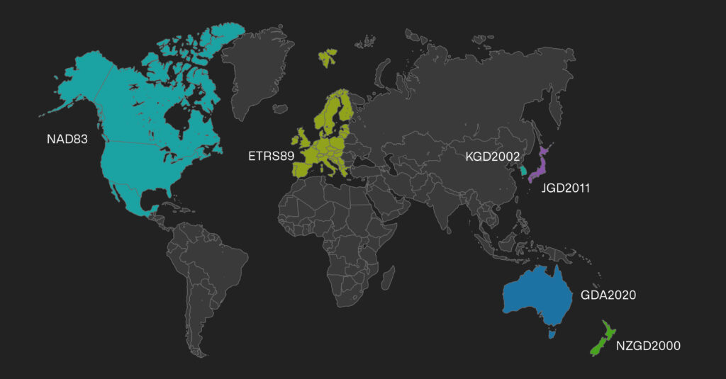
- You needed the ability to receive corrections in your preferred datum, whether that be NAD83, ETRS89, or KGD2002, for Polaris to work with your hardware and tools.
- To move forward, you’d require official support for your survey hardware.
Today, we have solved those challenges by inventing a creative solution to make your life as a product creator or surveyor easier. Keep reading – more on that below.
Struggling with poor UX and setup experiences on GNSS hardware
Many of today’s most advanced solutions for precision positioning were developed to serve every possible need without much thought for how customers actually use their product. Unfortunately, this means most corrections services for surveying are difficult to use and require hours of planning and setup.
If you are used to setting up a base station at every job site or location, you know this means carrying around that equipment to every job. And you likely lose hours at every job site configuring and calibrating these base stations.
If you are using a legacy RTK network or CORS networks, you’re likely familiar with the process required to plan every job in advance — finding your closest base station, looking up its mount point and connection credentials, and researching coverage. And then — at every site — configuring your survey equipment for each specific mount point means more time lost setting up and configuring your devices. On top of that, many of these networks are not reliable, requiring on-site adjustments. Even when you can use such a service, you find you’re locked into a vendor’s proprietary (and often expensive) network, requiring you to configure everything just right to get points in the grid you expect.
These challenges with legacy RTK networks also cause headaches for survey product creators. To deliver survey-grade precision, they’ve had to work with networks that don’t provide direct integration. And supporting a myriad of legacy networks, each with its own degree of accuracy, creates untold numbers of support tickets, explanation requests, and lost time for valuable sales and distribution partners.
There has to be a better way.
Centimeter accuracy that magically works on your devices — in the datum you expect
Today we’re officially launching support for GIS product creators, surveyors, and GIS professionals on the Polaris RTK Network — the most accurate, reliable network out there.
To do this, we’ve invented automatic assignment of datums and base stations. You connect to a single mount point, one time, and we make sure your devices are referencing the closest base stations and the appropriate local datum.
The best part? We’ve eliminated all the hassle from setting up, configuring, and using our service with the most common survey devices (with more to come). Here’s what you can expect:
- Survey-grade precision (cm-accurate) across the United States, European Union, United Kingdom, Australia, New Zealand, and Korea (and growing!)
- Connect your survey devices to Polaris in minutes — once and done!
- Never look up another mount point/base station again; Connect to a single mount point, and Polaris intelligently assigns you to your closest base station and provides results in the relevant datum for your continent/country.
- Support and automatic assignment of either ITRF2014 or local datums including NAD83, ETRS89, NZGD2000, GDA2020, JGD2011, and KGD2002.
- Save hours on every job site configuring and setting up base stations or harder-to-use RTK networks.
- Ditch the expensive base station rental or purchase.
- Untether your business from the constraints of geography and region.
- Connect to a fully managed network built entirely on industry-leading Septentrio receivers, with 99.99% uptime.
- Work on a network that is constantly growing, with over 100 new stations in the US this quarter alone.
- Get everything at one transparent monthly price — $150 a month or $1,500 a year.
- Significant pricing incentives for large fleets – contact us to find out more.
Behind-the-scenes during setup video filming day at the office
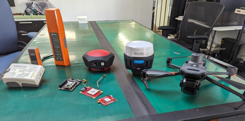
Are you using one of the most common survey devices out there? We have certified them to work with our network and created easy setup videos to guide you through the process (with more coming soon):
- Bad Elf Flex and Flex Mini
- Carlson BRx7
- DJI Mavic 3E
- Emild RS2+
- Eos Arrow Gold
- NovAtel OEM6, OEM7, SPAN, CPT7
- SparkFun RTK Facet
- Trimble R12
And low level modules, including:
Ready to give it a try? We’re offering a 14-day free trial — sign up today!
Incredibly easy API-integration for survey or GIS product creators
For product creators in the survey or GNSS hardware space, it’s been impossible to deliver a solution that “just works” once your customers open the box. With this new release, you can deliver a complete solution that gives your customers cm-accurate location with ZERO setup. Differentiate your products with unparalleled ease of use.
Here’s what you can expect:
- Get cm-accuracy that works for your customers out of the box with zero setup or configuration on their part in the US, EU, UK, AU, CA, and Korea (with more to come).
- Integrate with your survey device in an afternoon through our GraphQL API.
- Provision, manage, observe, and troubleshoot devices remotely at scale.
- Dramatically reduce support calls and time spent walking customers through complicated setup processes.
- Unlock additional recurring revenue streams by including RTK in your product as an upsell.
Are you ready to deliver a better product for your customers? Contact our sales team today.
Polaris in Action: Surveying, Mapping, Damage Prevention
How can you use Polaris for your survey or hardware business? While the use cases are too lengthy to catalog in a simple blog post, we’ve seen several patterns for use in the survey market:
- Site survey: Save time on base station setup and configuration. Get more jobs done in the same period of time.
- Damage prevention: Accurately locate and map underground assets and save time relocating those assets.
- Site inspection: Simplify the inspection of infrastructure and construction sites for faults and progress tracking.
- Mapping: Map using photogrammetry much more quickly and more accurately with precision location.
- Drones and robotics: Automate surveying, site marking, site mapping, and progress measurement with RTK-connected drones and robots.
Whatever the application, Polaris is poised to help you improve your survey business. Sign up today.