
As an established content creator and creative expert, Cameron Cone is no stranger to photogrammetry. Cameron regularly uses geospatial data to enhance the content he creates for clients, often leveraging his phone to capture LiDAR data and map 3D buildings to develop engaging marketing materials that allow consumers to virtually interact with a location.
When a real estate company tasked Cameron with marketing the story of a mixed-use development in Austin, Texas, he decided to create a 3D map for the client’s website so consumers could explore the vendors located across the district, ultimately helping them plan their visit. Given the scale of the undertaking, Cameron recognized that his traditional method of capturing LiDAR with his phone would be extremely time-consuming, not only for capturing imagery, but also referencing it to the correct location. After diligent research, Cameron chose to capture this information with the Maverick Pro Enterprise Drone and Point One’s Polaris RTK, a tech stack which enabled him to efficiently and accurately capture correctly georeferenced imagery and produce an actionable 3D map to drive consumer engagement for his client’s new site.
The need for high quality, scalable RTK
While the drone would enable him to capture imagery at scale, Cameron realized that operating it within a large area would entail navigating airspace constraints and time limitations, especially given the district’s close proximity to a hospital and airport. Regardless, he could not sacrifice capturing accurate imagery given photogrammetry’s strong reliance on accuracy and the significance of parallaxing in imagery for point cloud reconstruction. Cameron learned RTK would provide the location corrections he needed for the imagery to be accurately referenced on Earth’s surface, but was ineligible to access the State of Texas’ RTK network, which is reserved for use by government agencies.
After doing research into private RTK network providers, Cameron was impressed by Point One’s customer service and responsiveness. As someone who was new to the RTK world, he found the step-by-step help incredibly impactful while getting started. As he tested the Polaris RTK network, Cameron discovered he was able to achieve centimeter-level accuracy, a huge improvement from his phone’s foot-level data collection. This ability to capture high-resolution data to feed his content production led Cameron to rely on Polaris RTK as a critical tool in his 3D modeling moving forward with the real estate project.
Efficiently capturing high-precision map data with Polaris RTK
Without Polaris RTK, Cameron estimates that it would have taken him 5x times longer to capture high quality images for his client. Slower speeds would have generated inconsistent UV texture mapping stemming from fluctuations in lighting throughout the day, resulting in low quality building maps that would be unsuitable for the real estate company’s marketing content. However, with the integration of Polaris RTK, Cameron’s production time frame was cut in half. The image capturing’s speed allowed for swift capture of high-quality images, while concerns regarding SAT metadata drift became secondary.
After introducing Polaris RTK into his tech stack, Cameron not only saw a huge time savings in production, but also a 2-3X increase in his processing speed. “Rendering of that accuracy should have taken 48 hours just to get the point cloud system, with Polaris it was a little over three hours,” said Cameron. Where he previously had issues with capturing angles, RTK returned precise photogrammetry he could leverage to produce high quality client deliverables. Cameron explains, “I used to have to go back into the mesh polygons to edit errors, but now I can rely on Polaris RTK to produce better assets, and ultimately do less work post-production.”
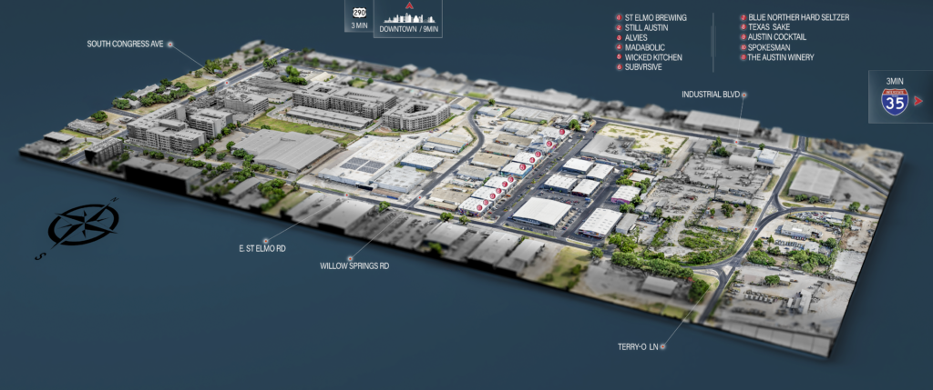
A sample of the 3D model Cameron Cone created as marketing content for his client, a real estate firm opening a new mixed-use development.
Continuing use for progress monitoring
As the multi-use district continues to expand, Cameron is confident that 3D modeling with his RTK-enabled drone will accurately capture the development’s evolution, helping consumers discover the businesses and amenities located there. While Cameron’s previous re-surveying methodology may have resulted in some distortions, Polaris RTK allows him to replicate the exact same flight plan each time to ensure consistency in updating the model. With Polaris RTK, Cameron can continue to provide his client with accurate, dependable, and efficient deliverables updates to their marketing content, driving consumer engagement to the new site and ensuring the strategic success of their development. This new tech stack has also unlocked a realm of new possibilities for Cameron as he serves his other clients, enabling him to scale his own content production and ensure client satisfaction.
Interested in how Point One Polaris RTK can enhance the accuracy and efficiency of 3D model creation? Get in touch here.