
Global Positioning Systems (GPS) are all around us, from within our phones and cars to our aircraft and space shuttles. However, Forbes reports that GPS has significant problems, including with accuracy, that will need to be addressed for the next generation of autonomous applications.
However, GPS is only one type of Global Navigation Satellite Systems (GNSS), and alternatives are growing rapidly, as groundbreaking new technology hits the market that boasts centimeter-level accuracy — hundreds of times more precise than the old fashioned GPS systems to which we’ve become accustomed.
One such technology is RTK (Real Time Kinematic), a solution that combines with existing GNSS constellations to provide far better accuracy, offering unparalleled location precision. However, with so many RTK Networks on the market, how do you pick the one that best suits your needs?
In this guide, we’ll explore the key factors to consider when selecting the optimal RTK system.
What is an RTK (Real Time Kinematic) Network?
Before diving into selection considerations, let’s establish a foundational understanding of what an RTK network is.
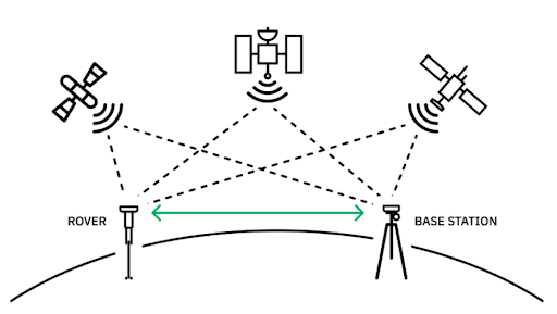
An RTK (Real Time Kinematic) Network offers unprecedented accuracy in real-time location data. It enhances the precision of GNSS positioning by providing real-time corrections to the standard GPS signals. While standard GPS has a positioning accuracy of roughly 2 feet at best, RTK offers centimeter-level positioning accuracy–a measure which stands to revolutionize industries that heavily rely on precise location information.
Here’s how it’s done: RTK relies on a base station that observes the same satellites as the mobile receiver found in your drone, surveying equipment, or robotics. The base station calculates errors in the satellite signals and sends correction data to the mobile receiver in real time.
This network facilitates highly precise positioning by continuously transmitting correction signals to the mobile receivers. Unlike GPS on its own, RTK with GPS corrects errors introduced by atmospheric conditions or satellite signals. This means it can provide a level of accuracy that far surpasses traditional GPS technology, making it the obvious choice.
How to Choose the Best RTK System
As the technology evolves, selecting the right RTK system requires considering many factors, from accuracy to ease of use, to ensure optimal performance.
Here’s a comprehensive guide to help you make an informed decision:
Why You Need the RTK Solution

For applications that require pinpoint precision, RTK is indispensable. RTK provides the utmost precision in location-mapping, offering an extraordinary leap forward for fields such as agriculture, robotics, surveying, construction, and even delivery logistics.
Take, for example, the recent revolutionary technological advancements in agriculture. Traditional GPS technology, while still widely used, falls short in meeting the stringent accuracy requirements. RTK-GPS systems allow the most precise data for crop mapping, field surveying, and tractor automation.
Robotics also benefit from RTK-GPS systems, which enhance autonomous navigation exponentially, ensuring precise positioning and path planning. For drone mapping, automated surveying, and robotic field operations, RTK is a must-have.
For large-scale mapping projects requiring topographic surveys, RTK provides an unparalleled level of accuracy, while for construction, RTK-GPS can be used for site layout, machine control, and monitoring structural movements. Even delivery logistics are improved with RTK-GPS. The days of relying on photo evidence of where a package was dropped off are behind us, as RTK-GPS aids in route planning, fleet management, and precision location for every drop-off.
The benefits of an RTK-GPS system don’t stop here. From utility and infrastructure to autonomous vehicles and beyond, the applications of this technology are endless, and are only just being explored.
Density & Accuracy
The accuracy of an RTK system is based on network density. Thus, the best RTK providers will have an abundance of base stations, which allow the most accurate positioning data. A high-density network ensures better coverage, reducing the likelihood of signal interruptions and enhancing precision, especially in challenging environments, such as cities or areas with more extreme weather.
Point One, for example, offers one of the densest networks in the country, with over 1,400 base stations across the globe–meaning centimeter-level accuracy at 99.99% reliability.
Protocol Support
Next, check for compatibility with different communication protocols. A versatile RTK system that supports various protocols ensures seamless integration with your existing equipment, enhancing flexibility.
However, some providers that offer their own RTK equipment (like receivers or drones) favor their own protocols. They may indicate that they are compatible with all protocols, but the performance with their proprietary protocol will likely be better.
If you already have existing equipment and are looking to layer in an RTK system, look for a provider that will work in tandem with your existing protocols. Point One is a leading example of a dedicated NTRIP/RTK provider that is compatible with existing protocols.
Navigation Constellation & Frequency Support
The more constellations and frequencies supported, the better the system can adapt to diverse geographical locations and atmospheric conditions. A diverse constellation of satellites, such as GPS, Galileo, GLONASS, and BeiDou, ensures global coverage.
Furthermore, different frequency bands have varying signal strengths and penetration capabilities, so RTK solutions that support multiple frequency bands can adapt to diverse terrains and obstacles.
If your product requires navigation of a challenging environment such as an urban area with tall buildings or dense vegetation, signal strength and penetration should be a top priority. Point One offers the ability to harness signals from multiple satellites and frequencies, ensuring a comprehensive and robust RTK solution for users across various industries.
Ease of Use
An RTK system that is user-friendly and intuitive reduces the learning curve for operators. This is especially important in industries where the professionals using the system may not have extensive technical backgrounds.
Products with intuitive interfaces and straightforward workflows should simplify troubleshooting and adjustments, reducing the likelihood of costly downtime during critical project phases. Prioritize a product with an easy-to-use API that provides straightforward and well-documented commands, functions, and protocols that developers and users can leverage to interact with the RTK system.
Try Point One, which boasts one of the most user friendly APIs on the market. Plus, operations in the web client and API are synchronized in real-time, enabling you to integrate the API with your systems while using our web client for the same devices and services.
![]()
Professionalism & Support
As with any emerging technology, reliable customer support and a robust professional network are critical to a seamless user experience and quick issue resolution. Beware of selecting an RTK system run by bureaucratic institutions that serve a variety of purposes. Often, these providers are run with limited resources.
If your business is built around precise location, then customer service and professionalism are paramount. Ensure that, when issues arise, you can get the immediate support needed to avoid costly service interruptions.
Security
Given the sensitivity of location data, prioritizing an RTK system’s security features is crucial. Make sure that the system you select adheres to industry standards and provides safeguards against unauthorized access or data breaches. Avoid sending data to a public source that is unencrypted–especially if you are dealing in sensitive data.
As the technology gets more sophisticated, so too do the threat actors. At Point One, the real-time security monitoring leverages technology while keeping humans in the loop, keeping your location data safe.
Cost
Consider the cost implications not just in terms of initial investment but also ongoing maintenance and support. While some providers are free, this usually comes at the cost of professionalism and ongoing support.
On the other hand, most dedicated RTK providers charge based on usage, which can quickly become costly. Point One stands out as a low cost dedicated RTK provider by providing unlimited plans only — use as much as you want, and pay one low fee per device.
You might also be thinking of building your own RTK system to keep costs low, but make sure you consider not just initial affordability but also ongoing performance and maintenance costs. Consider an existing state-of-the-art solution such as Point One.
Expansion Opportunities
The last thing to keep in mind is the scalability of your RTK system. A solution that allows for easy expansion with additional base stations or upgraded technology ensures future-proofing and adaptability to evolving requirements.
Furthermore, if you plan on taking your business overseas in the future, ensure that your RTK system can go with you. A product like Point One allows for expansion so that your RTK system can grow with your business. Point One has worked with various clients to make sure they have base stations set up where they need them, so they can access the location precision they need.
How the Point One Polaris RTK Network Works
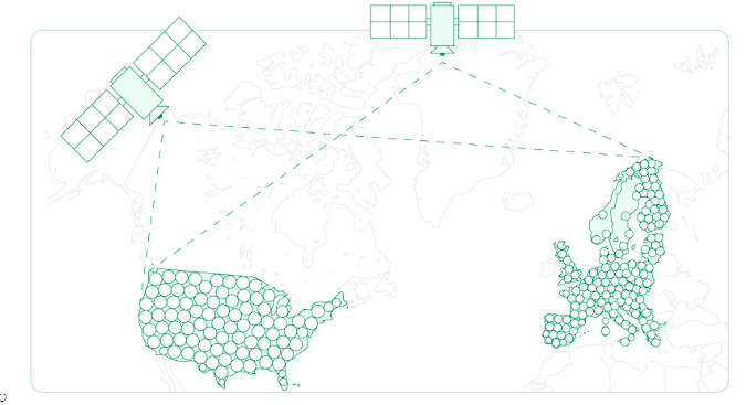
The Point One Polaris RTK Network provides one of the densest networks nationwide, ensuring unparalleled accuracy while maintaining cost-effectiveness. With a dense network of base stations, Point One offers unparalleled accuracy, user-friendly operations, and affordability–an exclusive combination in the market.
Unlike some RTK networks tied to specific receiver manufacturers, Point One prioritizes adaptability, ensuring compatibility with a diverse range of hardware from different brands. Point One Polaris RTK Network utilizes signals from GPS, Galileo, GLONASS, and BeiDou satellite constellations, enhancing accuracy by over 100x for a precise centimeter-level positioning with a 5 second correction time.
The Point One Polaris network comprises over 1,400 stations, spanning regions from the United States to Europe, Australia, and beyond. Point One is constantly investing in ensuring the network outperforms industry standards, and our customers are with us on our journey to provide the densest, most expansive network on the market.
With robust support in professionalism and security–and at one of the most affordable price points on the market–Point One establishes itself as a reliable partner for users seeking unmatched precision in location-based applications.
More About RTK Technology

RTK technology stands out as a transformative advancement in precision positioning. Let’s review some of the most frequently asked questions.
Is RTK better than GPS?
Yes, pairing RTK technology with your GPS system is far superior to conventional Global Positioning System (GPS). Standard GPS relies on signals from satellites, which have inherent inaccuracies. Meanwhile, RTK is able to compare signals received from satellites with those from the fixed base stations, resulting in centimeter-level accuracy. In other words, the RTK-GPS pairing far outperforms GPS on its own.
How accurate is RTK?
RTK networks can provide centimeter-level accuracy. While there are several GNSS correction methods, from RTK to PPP (Precise point positioning) to SSR (State space representation), none offer both the positioning accuracy and correction time of RTK.
RTK offers centimeter-level accuracy with a correction time of 5 seconds, making it the optimal choice for anyone seeking reliable and highly detailed location mapping.
How much do RTK GPS systems cost?
The cost of an RTK GPS system can vary widely depending on the features and capabilities offered. Basic RTK systems may start at a few thousand dollars, while more advanced and professional-grade solutions can range from several thousand to tens of thousands of dollars.
How many satellites are needed for RTK?
RTK positioning typically requires a minimum of five continuously tracked satellites. RTK relies primarily on a base station and a rover, reducing the number of satellites required. However, the more satellites that can be tracked simultaneously, the better the RTK performance – especially in challenging environments with obstacles or signal obstructions.
Which RTK is the Best?
When seeking the best RTK solution for your location precision needs, there are several factors to consider, ranging from density and accuracy, protocol support, navigation constellation and frequency support, ease-of-use, professionalism and support, security, cost-effectiveness, and finally to expansion opportunities.
The Point One Polaris RTK Network offers all of this and more. With a commitment to making precise positioning accessible, Point One eliminates the complexities associated with configuring networks and offers an easy-to-deploy network of base stations.