
When we think about construction projects, our minds are inclined to jump straight to the process of building. However, before a single brick is laid, there is a tremendous amount of work that goes into construction. The work that goes into mapping and staking out a construction site prior to laying any foundation is known as construction surveying.
In recent years, the use of robotics in construction has skyrocketed. From using RTK-enabled drones for mapping and surveying to the actual act of building, the applications of robotics in construction surveying stand to drastically improve the field.
In this article, we’ll explore the ins and outs of construction surveying to discover how cutting-edge technologies can improve it.
What is Construction Surveying?
Construction surveying is a vital component of the building process, ensuring accuracy in measurements, layouts, and infrastructure placement. Construction surveying refers to the process of staking out a construction site before beginning to build.
Before building, vertical and horizontal control is needed. A construction surveyor determines this by taking accurate measurements before the implementation of the project. It is necessary to stake out markers and reference points so that contractors understand where to place the structure, including vertical and horizontal positioning, dimensions, and configurations.
Tasks involved in construction surveying include research, reconnaissance, control, and mapping of the project area. The preliminary survey focuses on data collection and establishing a survey control scheme for construction.
The final task of a construction surveyor is to verify that the construction was built to the agreed-upon specifications and plans. This is known as an ‘as-built’ survey.
To get it right, construction surveying requires a high level of precision and accuracy. Given that one critical role of construction, surveying is to develop a precise map of the construction site, spatial positioning and mapping systems like the North American Datum of 1983 (NAD83) are often used by construction surveyors to establish common reference points for geographic data.
This ensures compatibility between various mapping and surveying efforts. NAD83 is commonly used in conjunction with the Global Positioning System (GPS) to facilitate accurate positioning and navigation.
However, these GPS systems are the most accurate when surveyors use GNSS corrections services, such as Real-Time Kinematic (RTK) technology. RTK correction is widely considered the gold standard in high-precision GNSS signal correction. This approach involves setting up a base station near the target area which then transmits a reference signal to the GNSS receiver, enabling precise positioning calculations
When survey robots are equipped with RTK data corrections, location precision can go from a few meters to a few centimeters–drastically improving GPS accuracy for construction surveying.
Construction Survey Example
Evidence of construction surveying can be seen in even the most ancient structures. From the Great Wall of China to Machu Picchu, it can only be assumed that early surveying techniques were involved to plan the exact angles and make the structure fit seamlessly into the land.
A more contemporary example of survey construction is involved when building highways. Prior to constructing a new highway, surveyors will mark the location, ensuring that the structure fits seamlessly into the landscape and preventing any possible damage due to existing infrastructure, such as gas or water lines.
Why Do You Need Surveying In Construction?
Surveying in construction is indispensable. It aids in accurate project planning, prevents potential damage to existing infrastructure, and ensures compliance with regulations. Surveyors go far beyond simply creating a flattened map of the site and measure everything with the utmost precision.
Traditionally, this process requires significant manpower. The integration of advanced surveying technologies is pivotal to meeting modern construction challenges effectively.
Advanced precision location software such as Point One’s RTK corrections network, Polaris, has greatly aided construction surveyors in risk analysis and damage prevention by providing real-time GNSS corrections to survey data.
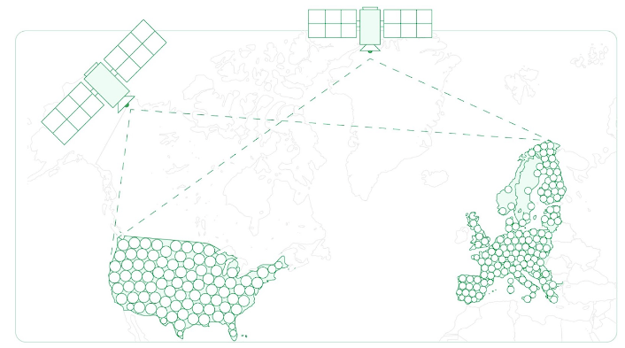
Surveying without RTK isn’t impossible, but it’s significantly more time- and labor-intensive and usually less accurate. With state-of-the-art solutions like Point One Polaris, which boasts a dense network of over 1,440+ base stations, the centimeter-level accuracy of positional data is game-changing.
Plus, with 99.99% uptime, lightning-fast convergence times, and unparalleled accuracy and reliability, Polaris offers affordable location precision without the hassle.
Equipment Used In Construction Surveying
Accuracy is paramount in construction surveying, requiring a selection of sophisticated equipment.
Control Stations
Control stations serve as a reference point for surveyors, providing a stable foundation for accurate measurements. These stations are strategically placed across the construction site to establish a reliable spatial framework.
Levels
Levels assist in determining height differentials and ensuring that structures are built on a level plane. This is crucial for the stability and safety of buildings and infrastructure.
Electronic Distance Measurements
Electronic Distance Measurement (EDM) devices enable precise measurements over long distances. This technology is instrumental in determining distances and angles between various points on the construction site.
Laser Scanning
Laser scanning technology captures detailed 3D images of the construction site, aiding in accurate mapping and visualization. It enhances the efficiency of surveying processes and contributes to better project planning.
GNSS Technology
Today, Global Navigation Satellite System (GNSS) technology plays a pivotal role in construction surveying by ensuring real-time positioning accuracy and facilitating efficient data collection. advanced GNSS correctional methods such as Real-Time Kinematic positioning bring precision in surveying to a whole new level, boasting centimeter-level accuracy.
How RTK Technology Improves Construction Surveying
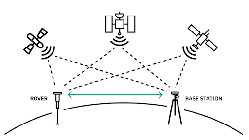
Real-Time Kinematic (RTK) technology is largely seen as the gold standard in GNSS correctional methods. RTK improves the accuracy of standard GPS systems from meter-level to centimeter-level precision by using a fixed base station to provide real-time corrections to GPS signals. For the construction surveyor who needs to know exactly where that water pipe is located to avoid major damage, this technology is indispensable.
The applications of drone RTK on construction surveying are only just being uncovered. RTK-enabled drones help with site planning by providing precise data that helps reduce costly errors, ensures compliance with regulation, and ultimately enhances the efficiency of the construction surveying process in ways that reduce overall labor costs.
Positional Accuracy
RTK GPS ensures the utmost positional accuracy, which is vital for tasks like foundational layout, ensuring structures are aligned correctly. Traditional GPS is accurate within roughly 5 meters, which on its own is useless data for a construction site. Thus, the surveyor is required to take much more accurate measures to prepare a construction site.
With RTK corrections using advanced technologies like Point One Polaris, that level of accuracy changes tremendously, to the centimeter level. This type of positional accuracy completely transforms the role of the surveyor from one who has to manually lay stakes to one who receives and interprets a highly precise set of location data.
Real-time Corrections
The real-time correction capabilities of RTK technology enable surveyors to make immediate adjustments based on accurate data. GNSS provides initial location data to surveyors based on satellite signals. However, this data isn’t always complete, since it can be affected by environmental or technical issues.
Thus, most surveyors take steps to correct this data using a GNSS correctional method. RTK technology is the GNSS correction method that’s best at providing real-time corrections with tremendous accuracy.
This ultimately minimizes errors and enhances efficiency during construction, especially when leveraging a product like Point One Polaris, which has one of the densest networks of base stations in existence.
More Questions About Construction Surveying
Construction surveying is a critical step in the construction process. Let’s review the basics.
What is the meaning of surveying in construction?
Surveying in construction is ultimately about having an accurate map of the construction site before beginning to build. The jobs of a construction surveyor involve research, reconnaissance, control, and mapping.
What is the objective of a construction survey?
The primary objective of a construction survey is to provide accurate and comprehensive spatial data for project planning and execution. This includes site layout, infrastructure positioning, and adherence to safety regulations.
Additionally, construction surveying mitigates damages in the process by locating and mapping existing infrastructure that could pose a risk to the construction project.
What is site surveying in construction?
Site surveying in construction involves a detailed examination of the construction site, considering topography, existing structures, and potential obstacles. While this traditionally required a significant amount of manual labor from mapping to staking, in today’s world, drones equipped with RTK have significantly enhanced the site surveying process.
These technologies have turned site surveying into an automated process with extreme precision and accuracy.
Access Precision Location for Your Construction Surveying
To achieve ultimate precision and efficiency in construction surveying, the integration of RTK GPS is a must-have. With the enticing promises of RTK technology, It’s alluring to attempt to build your own RTK system. However, in reality, the cost, complexity, reliability, and user experience of this choice make it less than desirable.
Instead, turn to an existing, state-of-the-art, affordable RTK solution. Point One Polaris provides unparalleled GNSS accuracy and centimeter-accurate positioning on surveying robots and drones. The integration of this cutting-edge technology in construction surveying enhances accuracy, minimizes risks, and contributes to the success of construction projects–all at an affordable price.
Check out the Polaris station network to bring consistent and dependable corrections to your construction surveyors today.