
This is especially evident during the solar maximum, a period of peak activity in which the sun’s blistering-hot surface erupts with explosive solar flares, rages with solar storms and coronal mass ejections, and hurls fast-changing solar winds throughout the solar system. This intense activity affects Earth in a variety of ways, many of which are imperceptible to the naked eye.
The solar maximum can have a particularly potent impact on satellite systems in Earth’s orbit, including the Global Navigation Satellite Systems (GNSS) we use to measure the position of objects on the ground. For industries that rely on highly accurate measurements, such as construction surveying, autonomous delivery vehicles, drone mapping, and agriculture, these disruptions can be highly consequential.
Since we’re heading into a period of solar maximum in 2024, this celestial phenomenon is particularly relevant for businesses in these and many other industries right now. Understanding the solar maximum and its impact on GNSS measurements can help shed light on the best way to mitigate its impact.
What Is the Solar Maximum?

In 2024, we’re entering a period of intense solar activity that will affect GNSS positioning estimates in significant ways.
The solar maximum is a period of heightened activity that comes at the peak of the solar cycle. Preceded at the beginning of the cycle by the solar minimum, a period of low activity, the solar maximum builds toward peak activity and recedes, lasting up to several years. In total, the entire solar cycle lasts roughly 11 years, though the exact length varies from one cycle to the next.
During periods of solar minimum, the sun’s magnetic field is relatively stable, containing and stabilizing the highly ionized plasma on the sun’s surface. During the solar maximum, the sun’s magnetic field becomes twisted and unstable and eventually flips poles entirely, causing intense activity on the sun’s surface and its surrounding corona. This leads to:
- Massive solar flares: Eruptions of electromagnetic radiation appearing in the visible spectrum as bursts of light around the sun’s surface.
- Intense coronal mass ejections: Expulsions of bubbles of plasma from the sun’s surface that appear as strands of fire unfurling from the sun.
- Increased solar wind variation: Streams of protons and electrons continually flow through the solar system, and these solar winds can fluctuate heavily in density and structure during the solar maximum.
The intensity of these solar phenomena varies by cycle. The most recent solar maximum peaked in 2014 at relatively low levels of solar activity, while the previous peak in 2002 saw much greater solar unrest. Likewise, it’s not easy to predict exactly how long the cycle will last or when the solar maximum will occur. The current cycle — cycle 25 — began in 2019 and was originally forecasted to peak in 2025 at a similar level to cycle 24. However, scientists noted increasing solar disturbances last year, moving predictions for the next solar maximum to 2024, with more intense and extended activity than originally anticipated.
The Solar Maximum and GNSS Signals

During solar maximum, the sun’s unstable magnetic field results in intense solar flashes, coronal mass ejections, and solar wind fluctuations that reach all the way to Earth.
The effects of the solar maximum extend far beyond the sun, bombarding Earth with radiation and magnetic activity. These effects can be captivating, such as the increase in visible auroras farther from the poles. But they can also be dangerous, posing radiation risks to pilots and astronauts or inducing major power outages.
Between these extremes — but still highly impactful to a range of important industries — is the effect of heightened solar activity on the satellites in Earth’s orbit. Disturbances in the ionosphere, the outermost layer of the Earth’s atmosphere, are especially strong during the solar maximum.
During the day, the sun’s radiation causes electrons to break loose from atoms in the upper atmosphere. This ionization creates a surge in total electron content (TEC), which is the number of free electrons along a cross-section between two points. At night, many of these electrons and ions recombine, lowering the ionization level.
These surges in TEC increase in number and intensity during solar maximum, as bursts of radiation and plasma, and highly variable, magnetic solar winds surge toward Earth from the sun. With enough turbulence, the fluctuations can be categorized as ionospheric storms. This uptick ionospheric disturbances can also lead to “bubbles” or “plumes” in the ionosphere — large-scale density variations caused by a generalized Rayleigh-Taylor instability (think oil bubbles in water) that deflect and/or scatter signals. The effect on signals is called scintillation. When this is especially prominent, receivers may be entirely unable to navigate.
Whatever the level of disturbance, these changes in TEC can noticeably affect the propagation of GNSS signals as they move through the atmosphere. This leads to discrepancies in the receiver’s propagation models — leading to measurement errors in the range of several meters. Again, these disruptions and errors are common at all times, but they’re more frequent during the solar maximum.
For everyday applications like mapping your route with a GPS signal on your phone, these disturbances don’t generally have major significance. In commercial applications, however, the effects can be devastating. Consider, for instance, a construction dig that’s off by 2 meters — possibly the difference between laying the foundation and breaking an underground utility line. Or, envision an autonomous delivery vehicle that drops a package 2 meters from its intended location.
It’s also worth noting that intense solar activity can cause disruptions to radio frequencies (RF) and increase drag on satellites in Earth’s lower atmosphere. Although RF interference can affect GNSS measurements (as we’ll explore below), the effect of drag is minimal at MEO altitudes, where navigation satellites reside.
Offsetting the Impact of the Solar Maximum on GNSS Positioning
These disturbances aren’t unique to the solar maximum — and a solution for achieving precise positioning estimates is essential regardless of the current level of solar activity. That said, there are a few ways to ensure you have the most precise navigation solutions possible.
1. Robust Receiver Designs
Radio frequency interference from solar activity can create RF noise, which decreases receiver accuracy. If this noise isn’t filtered out, the GNSS observables may be rendered unusable.
The best modern receivers are capable of offsetting this signal noise and “cleaning it up” to ensure the GNSS signal is accurate and usable. Working with a receiver equipped with these capabilities is a prerequisite to fine-tuning your GNSS positioning estimates.
2. Multi-Constellation Reception
GNSS positioning estimates are always more accurate when derived from multiple sources. This is especially true during intense periods of solar activity, when TEC may have steep regional gradients or have localized irregularities that cause scintillation.
By making observations of multiple different satellites in constellations such as GPS, GLONASS, Galileo, and Beidou, a receiver has access to many more independent measurements from more satellites in the sky. This geometrical diversity of measurements allows the receiver to better protect the positioning solution from the deleterious effects of ionospheric activity. The corrections network you rely on should collect signals from multiple constellations to ensure position estimates are as accurate as possible.
3. Precise Differential Corrections
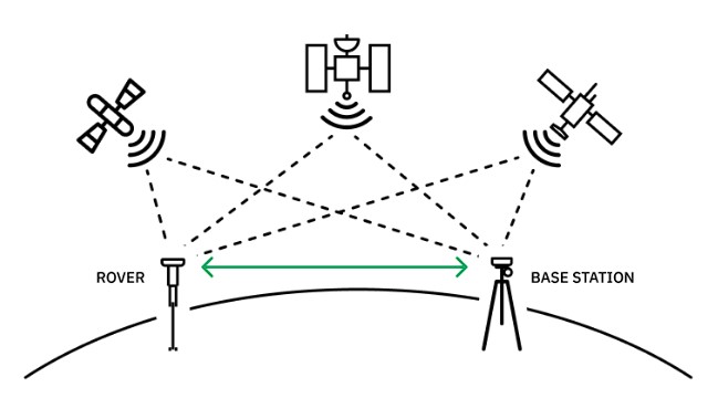
RTK relies on a fixed base station with observables from multiple satellites, allowing for positioning estimates that are accurate within a centimeter, even with high atmospheric disturbances.
Finally, there’s the corrections network itself. And for the type of network, you’ve essentially got three options:
- Precise point positioning (PPP): PPP uses a network of base stations to estimate models for the largest effects on satellite code phase. However, this leaves all the work of estimating carrier phase error models to the rover receiver. Convergence of these local error models may take 20 minutes or more.
- Real-time kinematics (RTK): RTK relies on a large network of precisely located base stations. When GNSS receivers are within range of a base station (the closer, the better), the station’s local observations can be used to cancel propagation model errors from ionospheric disturbances or other issues.
- State space representation (SSR): SSR is newer to the corrections landscape and provides a highly detailed model of signal propagation errors. However, standards for conveying SSR data are in their infancy and very few receivers can interpret SSR data natively. This leads companies to convert the SSR data into synthetic measurements at virtual base stations so the receiver can treat it as RTK data.
While no setup can perfectly mitigate against the disruptions caused during the solar maximum, RTK is better positioned than other options to maintain accurate position estimates. With a large enough network of base stations, RTK can deliver centimeter-accurate positioning from virtually anywhere.
Prepare for the Solar Maximum With Point One
Ultimately, however, RTK positioning is only as helpful as the network powering it. And here, Point One’s Polaris RTK Network is uniquely positioned to help you stay on course during times of high solar activity. Let’s look at three reasons why.
Low-Latency/High-Frequency Base Station Measurements
When ionospheric disturbances are relatively low, you can achieve accurate position estimates using observables as much as 30 seconds old. Free public CORS RTK networks provide that level of latency.
However, when ionospheric activity is high, you need more frequent signals with lower latency to reflect the dynamic changes to the ionosphere. Polaris base stations send base station observations every second, with typical latency less than four hundred milliseconds, providing more current data on which to base your positioning estimates.
Higher Spatial Density
While its high frequency and low latency sets Polaris apart from public RTK reference systems, its base station density is what distinguishes it from other commercial RTK services.
Again, for RTK to be as accurate as possible, you need a base station as close as possible to where you are working. The closer you are, the smaller the residual errors will be after canceling out the bulk of common-mode measurement errors between you and the base station. Within the Polaris network, there are more than 1,400 base stations across the globe — and over 1,200 within the U.S. alone. That means you’re usually never more than 50 kilometers away from a base station, and even closer within heavily populated areas.
Physical Base Stations
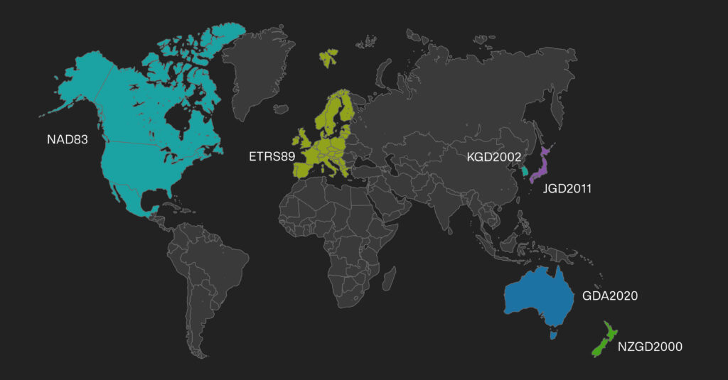
The Polaris RTK network is the largest in the world, with more than 1,400 base stations available in North America, Western Europe, South Korea, Japan, Australia and New Zealand.
Finally, Polaris offers an advantage over those RTK networks that rely only on virtual SSR measurements to supplement some of their positioning data. While SSR can provide accurate positioning estimates in many cases, it comes up especially short during a time of high solar activity. Many SSR models were developed during the most recent period of solar minimum. As a result, they have never been vetted during a period of higher ionospheric activity associated with solar maximum.
There are two further complications with SSR that make using a dense network of physical base stations attractive during solar maximum. The physical networks that estimate SSR models frequently use long baselines — hundreds of kilometers — between stations. These longer baselines are entirely adequate when the ionosphere is quiet, but make it impossible to observe higher spatial frequency variations in the ionosphere. Also, the SSR models themselves may be incapable of representing the variations in ionosphere between stations.
In contrast, Polaris offers what you might call “True RTK.” Rather than relying on synthetic observations from virtual reference stations, Polaris uses a dense network of real, physical base stations. Polaris corrections account for the impact of ionospheric activity in real time. There’s no guesswork involved.
Are You Ready for the Solar Maximum?
The solar maximum comes and goes every 11 years or so, and it has done so since long before we knew how to measure these cycles. But this latest cycle is a reminder of just how important accurate GNSS measurements have become in so many industries. Whether it’s autonomous driving, construction surveying, or drone mapping, companies of all kinds can’t afford to let heightened solar activity get in the way of precision.
No RTK solution can entirely account for extreme ionospheric activity or severe scintillation during the solar maximum. But relying on a dense network of close-proximity, physical base stations with frequent corrections will set you up for better positioning estimates. The Point One Polaris RTK Network is built to provide centimeter-accurate corrections, no matter what the sun sends our way. See it for yourself — start a 14-day free trial today.