
Underground Utility Locator Guide [2024]
There’s at least one underground utility strike in the United States every minute, resulting in significant damage to well-being and properties, financial loss, and service disruptions. Underground utility locators minimize the occurrence of these strikes by identifying and mapping pipes and cables buried in the ground.
This guide will help you understand underground utility locators, including the difference between public and private utility locating. It also equips you with knowledge about three of the most efficient methods and techniques for underground utility locations. It also reviews how you can significantly enhance the accuracy of your underground utility locators using real-time kinematic (RTK) technologies.
What are Underground Utility Locators?
Underground utility locators are techniques and tools used to search for and map underground utilities such as water, gas, and electrical lines. These locators are specifically built to detect and accurately pinpoint the location of these utilities to prevent damage during excavation and construction activities.
Why are underground utility locators necessary? Once the exact location of underground utilities in the area has been identified, surveyors and mappers can accurately locate these underground facilities with markers that may be temporary paint, flags, or durable stakes, usually made of plastic or metal.
This makes it relatively easy to avoid these identified locations during construction.
Private vs Public Utility Locating
Private utilities are owned and managed by non-government agencies. They include telecommunications cables, industrial gas lines, and private water systems and are usually found in residential homes, commercial buildings, and industrial areas.
Public utilities are managed by government agencies; these utilities include water mains, sewage pipes, and electrical lines. With public utilities, you can get a map of underground utilities on your construction sites with a single call.
For instance, in the United States, you must call 811 to inform them of your project so they can provide a map of underground utilities on your site or even come and map out the location of these utilities for you.
Unfortunately, this is not the same with private utility locating, where several companies may be responsible for installing different underground utilities and will only map those installed by them.
Common Underground Utility Location Methods
Regardless of your underground utility location methods, you will still need to use RTK to get extremely accurate results. However, surveyors mainly use two types of underground utility locators: electromagnetic locators and ground-penetrating radars, and you can use these alongside Polaris RTK.
Ground Penetrating Radar
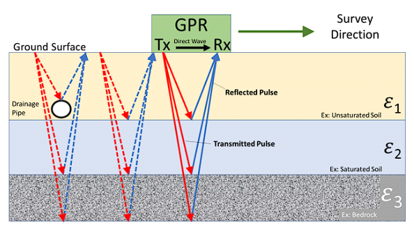
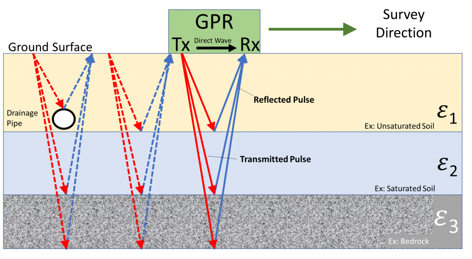
Ground-penetrating radar (GPR) uses radar pulses to image underground utilities. These devices consist of a transmitter and a receiving antenna. The transmitter emits electromagnetic waves into the ground, which detects signals from underground utilities and sends them back to the GPR receiving antenna. The receiving antenna records the variations in the signal returned to identify the presence of underground utilities.
GPR devices can receive signals from concrete, asphalt, pipes, and cables underground. Based on the variations in the signal received, users can often identify which signals come from an underground utility and which are from natural underground formations such as rocks or layers of soil.
Benefits
- Non-intrusive method for locating underground utilities
- GPR is effective in locating both conductive and non-conductive underground utilities
- GPR devices have a higher accuracy compared to traditional electromagnetic locator methods
Limitations
- Penetration depth reduces with an increase in the frequency transmitted
- The device antenna has to be in contact with the ground for a strong signal
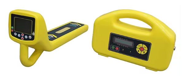
Electromagnetic Utility Locating
Electromagnetic utility locators, also called EM locators and cable locators, are a method of underground utility location that usually involves direct contact with the underground utility via a part of the utility conduit that is available above ground. This can be a connecting valve or an exposed part of the underground utility. The device uses electromagnetic induction to detect electromagnetic fields generated by electrical lines using a transmitter and a receiver.
The transmitter connects to the utility line via a part of the line above the ground and then transfers or injects a frequency or signal into the line. The receiver then detects and pinpoints the location of the utility line from above the ground. It also traces the line's path accurately so construction and excavation teams can avoid damaging the utility during their work.
Benefits
- Technicians and engineers can tell which pipes are being located
- It is best for locating underground electrical cables
- Modern EM locators have features for filtering signals
Limitations
- It requires physical access to the part of the pipe that is above ground (e.g., the valve or an exposed pipe)
- Special training is required for operators of EM locator devices as these devices are often deployed to locate dangerous lines
Hydro or Vacuum Excavation (Potholing)
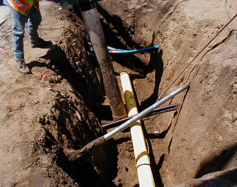
Vacuum excavation is an intrusive yet non-destructive method for locating underground utilities. It works like a vacuum cleaner, sucking soil from the earth to reveal the utilities buried underground. This method is accurate as users above ground can see the utilities clearly, but it is labor intensive.
There are two methods of potholing: air vacuum excavation and water vacuum excavation. With air vacuum excavation, compressed air is blasted into the ground to loosen the soil before vacuum excavation. Water vacuum excavation on the other hand is used on very hard soil. It is sprayed into the soil with a high-pressure nozzle, then a vacuum is used to extract the loosened soil and water mixture.
Benefits
- It is safe and environmentally friendly, with no emission of high frequencies or electromagnetic waves
- Works best in areas with sensitive and congested underground utilities
- Vacuum excavation has minimal impact on the surrounding site
Limitations
- It can be more time-consuming than other excavation methods
- Weather conditions, like heavy rain or freezing temperatures, can affect the efficiency of vacuum excavation
How to Improve the Accuracy of Underground Utility Locators
The easiest and most efficient way to improve the accuracy of underground utility locators is by creating real-time utility maps. But this is not always the case.
With traditional utility location, one would have to send out a locator to put some flags in the ground indicating the presence of underground utilities, and then a second person (surveyor) would then map out where these utilities are located.
Fortunately, with RTK technology, surveyors can enable RTK services on their utility locators to identify and map out the location of underground utilities in real time, as well as correct errors in standard satellite data for precise positioning. Basically, RTK-enabled utility locators simultaneously record the exact location of underground utilities as they are identified by your locator–with centimeter-level accuracy.
You can also use NTRIP services by Point One Navigation to enhance the real-time precision of your utility location devices, enabling the creation of highly accurate utility maps in real time.
More About Underground Utility Locating
Let’s take a look at some FAQs on utility locators.
What number can be called to find the location of underground facilities?
The number to call to find the location of underground facilities in the US is 811 and it is mandatory to call this number before you dig, whether you want to dig up a tree in your courtyard or you are a construction company carrying out excavation works. However, 811 only provides details on public utilities.
How to detect underground services?
Underground services can be detected using utility detection devices. These devices work with various techniques including vacuum excavation, electromagnetic locators (EM), and ground penetrating radars (GPR).
What is the best method for locating buried utilities?
The best method for locating buried utilities is combining Point One’s Polaris RTK with GPR and EM devices to pinpoint exact locations and depths with the highest accuracy.
How does a utility locating equipment work?
Most utility locating equipment works by emitting signals into the ground and detecting the reflections or disruptions of those signals caused by buried utilities. The specific method for locating underground utilities can vary depending on the type of equipment used; for example, electromagnetic locators use electromagnetic fields to detect metal objects, while ground penetrating radars (GPR) emit radio waves to detect various types of utilities.
What is the best underground utility locator?
The best underground utility locators are GPR and EM location devices, such as the Proceq Subsurface GPR GS8000 and the MALÅ Easy Locator Core which can penetrate dense materials and provide precise location data.
Streamline Your Underground Utility Locating
Electromagnetic locators (EM locators) and ground penetrating radars (GPR) are two of the best ways to locate underground utilities. While electromagnetic locators (EM) are great for detecting metallic pipes and cables, ground penetrating radars (GPR) work excellently in identifying non-metallic objects and assessing the depth of utilities.
Finding the underground utilities is just the first step–often you need to map the location of these utilities so they can be found later. The best way to do this is with highly accurate precision location.
Improve the accuracy of your location data when you use your EM or GPR utility locating devices and equipment. How? Polaris RTK from Point One Navigation.
PointOne Navigation offers Polaris RTK, a state-of-the-art RTK solution for unparalleled accuracy. It offers:
- Centimeter accuracy
- Coverage across the US, EU, UK, CA & AU
- Universal GNSS device connectivity
- TrueRTK
- Automatic assignment to nearest base
- ITRF2014
- Automatic local datums: NAD83, ETRS89, NZGD2000, GDA2020, JGD2011, KGD2002
- Works with ANY dual band RTK-enabled device
With Polaris RTK, you get centimeter-accurate positioning, lighting-fast convergence times, and 99.99% network uptime.