

TL;DR
Underground wire and cable locators detect buried utilities using electromagnetic signals or ground-penetrating radar. When paired with an RTK correction network and a digital mapping platform, they let a single crew locate a cable and deliver GIS-ready, centimeter-accurate coordinates the same day. This article covers six locators across price points from $36 to $7,000+, how RTK corrections improve locating accuracy and safety, and the proven Radiodetection RD8200 SG + PointMan + Point One RTK workflow that has reduced utility strikes by up to 97% on documented projects.
The 2023 Common Ground Alliance DIRT report documented $30 billion in utility damages in a single year. Approximately 500,000 utility strikes occur annually in the United States, and the number is trending up. More infrastructure spending means more excavations in congested underground environments, and the complexity compounds every year because old utilities rarely get removed when new ones go in.
Underground wire and cable locators are the first line of defense. When paired with an RTK correction network and a digital mapping platform, they go further: a single crew can detect a buried cable, record its centimeter-accurate coordinates, and deliver a GIS-ready file the same day, without a second survey trip.
This article covers how underground cable locators work, which method fits your project, and six models worth evaluating, including one purpose-built for RTK-enabled mapping workflows.
What Is an Underground Cable or Wire Locator?
An underground cable or wire locator is a specialized instrument that detects buried cables and pipes by emitting and receiving electromagnetic (EM) signals. Most systems include a transmitter and a receiver. The transmitter couples a signal onto the target cable; the receiver tracks that signal above ground to reveal the cable’s path, depth, and direction.
Some locators integrate global navigation satellite system (GNSS) receivers, which allows field crews to record geographic coordinates at each detection point. When that GNSS receiver connects to a real-time kinematic (RTK) correction service, those coordinates reach 1 to 2 centimeter accuracy rather than the 1 to 3 meter accuracy of uncorrected GPS. That difference matters when a buried cable runs within arm’s reach of a proposed excavation line.
For a broader overview of detection methods including ground-penetrating radar and vacuum excavation, see our underground utility locator guide.
Why Utility Locating Is a Data Problem
For decades, the standard utility locating workflow looked like this: mark it, sketch it, email it, hope the file is available later. Every handoff introduced error or latency. By the time location data reached the engineer, it had been transcribed, reformatted, or lost.
The underlying issue is not effort. Strikes happen even when the locate was performed and the mark went down. The problem is that paint on the ground is not data. Traditional paint marks are temporary, accurate to roughly one meter on either side due to human error and environmental factors, and carry no geospatial metadata that downstream teams can use.
Legislation is catching up. In January 2021, the Colorado Department of Transportation mandated sub-inch accuracy for utility locating, along with standardized datums, coordinate systems, and TMOS codes. ASCE standards are raising the bar for GIS-ready deliverables across the industry. Companies winning work today are those that can deliver RTK-georeferenced records same-day. States following Colorado’s lead will require the same.
The practical result: the locate and the mapping step are collapsing into one. RTK-enabled cable locators make that possible by capturing precise coordinates at the moment of detection. For more on this shift, read Utility Locating Is a Data Problem.
How to Find Underground Electric Wires and Cables
Three approaches are commonly used, each with different tradeoffs in cost, accuracy, and turnaround time.
Underground locator devices are handheld instruments that crews operate directly in the field. They use electromagnetic induction (EMI), ground-penetrating radar (GPR), or a combination of both. EMI models are the most common for wire and cable work because they couple directly onto metallic conductors.
Underground wire locator rental makes sense for one-off projects where equipment investment is hard to justify. The tradeoff is limited time to learn the instrument before field deployment.
Underground wire locator companies bring experienced crews and specialized equipment but add scheduling dependencies and higher per-project cost.
Whichever approach you use, RTK-enabled locators provide a concrete operational advantage: a single crew member can locate and map a utility simultaneously, rather than sending a locate crew first and a mapping crew afterward. Traditionally, two-trip workflows were the norm, and every handoff between trips introduced transcription error or data loss. RTK-enabled single-trip workflows eliminate that gap entirely.
Best Underground Wire and Cable Locators
The six models below cover a range of price points and use cases. Models 1 through 5 are general-purpose electromagnetic locators at various price points. Model 6, the Radiodetection RD8200 SG, is purpose-built for simultaneous locate-and-map with integrated survey-grade GNSS, and is the locator at the center of Point One’s utility mapping workflow with PointMan.
1. Amprobe AT-3500 Underground Cable Locator
The Amprobe AT-3500 locates both energized and de-energized cables underground. It includes a receiver, transmitter, connection cables, and a ground stake for establishing a reference point. An audible signal strength indicator and backlit bar-graph display support operation in low-light environments. The AT-3500 uses 33 kHz as its primary active frequency, which Amprobe considers the most reliable general-purpose locating frequency.
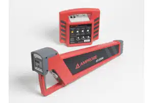
Specifications:
- Maximum depth: 16 ft (4.9 m)
- Active frequency: 33 kHz
- Passive modes: power (50/60 Hz) and radio
- Semi-automatic gain control
- Power: batteries
Price: approximately $3,375
2. Vevor 3′ Underground Cable Locator
The Vevor 3′ locator detects non-energized cables carrying less than 24 volts. It weighs under 1 kg, making it practical for extended carries, and includes wired headphones for use in noisy environments. Its price point suits small residential and low-voltage projects where a professional EMI locator is not warranted.
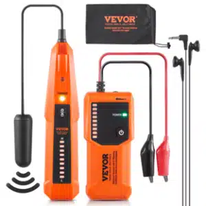
Specifications:
- Detection depth: 3 ft
- Maximum detection length: 1,000 ft
- Cable types: single-core, dual-stranded, non-energized, low-voltage (24V or below)
- Operating temperature: 32°F to 104°F (0°C to 40°C)
- Receiver dimensions: 7.9 x 1.6 x 1.2 in
Price: approximately $36
3. Noyafa NF-826 Underground Cable Locator Pipeline Detector and Wire Tracker
The Noyafa NF-826 handles underground wire locating and metal pipe detection in one instrument. Its integrated AC/DC voltmeter measures 12 to 400V, enabling detection of breaks and short circuits in addition to cable path tracing. A built-in LED light supports operation in dark access points.
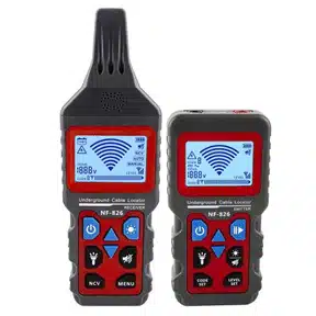
Specifications:
- Maximum detection depth: 2 m (80 in)
- Maximum cable length: 1,000 m
- Voltage measurement: 12 to 400V AC/DC
- Battery: 3.7V, 1,400 mAh lithium-ion
4. Tempo 501 Tracker II Underground Cable and Wire Locator
The Tempo 501 Tracker II supports three connection methods: direct connection via leads on the target cable, inductive coupling on a live cable, and passive detection via an internal inductive antenna for inaccessible cables. It locates dead and active cable lines, metallic pipes, and conduits. Both visual and audible signal strength indicators are standard.
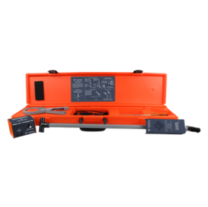
Specifications:
- Transmitter battery life: 30 hours nominal
- Receiver battery life: 10 hours nominal
- Transmitter frequency: 447.5 kHz
- Auto shutoff: 90 minutes (transmitter and receiver)
- Weight: 6.7 lb
Price: approximately $767
5. Leica DD120 Underground Utility Locator
The Leica DD120 is an entry-level battery-powered utility locator that detects underground utilities to a depth of 3 meters. It operates in power and radio passive modes without a transmitter, and supports active locating when paired with a DA220 or DA230 signal transmitter. An in-built self-test checks device health before deployment, and the instrument alerts crews when a service is within 30 cm of the locator. Note: Leica’s current flagship is the DD300 CONNECT, which adds Bluetooth data transfer and app integration for teams needing a path toward digital mapping.
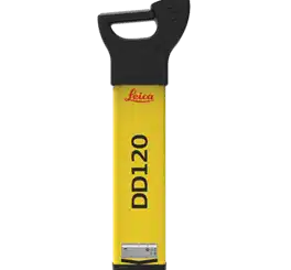
Specifications:
- Maximum detection depth: 3 m (10 ft)
- Depth accuracy: 10%
- Operating time: 15 hours
- Power: 6 x LR6 (AA) alkaline batteries
- Display: monochrome numeric signal strength
Price: approximately $1,150 to $1,300 (locator only)
6. Radiodetection RD8200 SG Survey-Grade Locator
The Radiodetection RD8200 SG is the locator most relevant to RTK-enabled utility mapping workflows. It builds on the proven RD8200 platform and adds an integrated high-accuracy GNSS antenna with automatic antenna offset correction, so crews do not need to tilt the unit back to capture a coordinate point. A single button press captures a georeferenced point and transfers it via Bluetooth to a connected mobile app. It supports any NTRIP correction service and any compatible mobile mapping application, and works directly with the Point One RTK Network and PointMan.
Specifications:
- Integrated survey-grade GNSS antenna with automatic antenna offset
- IP54 dust and water resistance
- Battery life: up to 14 hours continuous use
- Locate accuracy: +/- 3% of depth within first 10 ft; +/- 5% from 10 to 20 ft
- Active frequencies: 256 Hz to 200 kHz
- Weight: 2.4 kg (5.2 lb)
- Compatible with Android and iOS mapping apps
- Works with any NTRIP correction provider
Price: contact Radiodetection or an authorized distributor for current pricing
Best for: utility locating teams that need to deliver RTK-georeferenced, GIS-ready records same-day.
How RTK Corrections Improve Underground Cable Locating
Standard GNSS positioning introduces 1 to 3 meters of error in typical field conditions. For utility locating, that margin is a safety liability: a buried cable running within 0.5 meters of a proposed excavation is well inside uncorrected GPS error. RTK corrections close the gap to 1 to 2 centimeters.
RTK works by streaming real-time correction data from a ground-based reference network to a rover receiver in the field. The rover applies those corrections continuously. Accuracy degrades as the distance between the rover and the nearest base station increases: single-baseline RTK loses roughly 1 to 1.5 cm of accuracy per 10 km of additional baseline, with performance becoming unreliable beyond 20 to 35 km. This is why network density determines real-world RTK performance, not just coverage area. Sparse networks capture broad atmospheric patterns but miss the localized ionospheric and tropospheric disturbances that drive positioning error. Dense networks capture both. No correction method, whether single-baseline RTK, Network RTK, or SSR, can recover information the station network has not measured. For the physics behind this, see Demystifying Network RTK: Why Density Matters.
The Credential Problem That Slows Field Adoption
One barrier that comes up consistently in practice: RTK networks historically required field technicians to manage mount points, credentials, and server configurations manually. Teams operating across regions juggled different credentials per coverage area, and failed connections meant falling back to 10-foot GPS accuracy.
The PointMan integration with the Point One RTK Network solves this directly. Field users select “Point One” from a dropdown inside the PointMan app. Mount points, ports, and server configuration are handled automatically through the Point One GraphQL API. A technician who has never configured NTRIP settings can be collecting centimeter-level data in under a minute.
What RTK-Enabled Locating Makes Possible
Single-crew locate-and-map. The crew traces the cable and simultaneously records centimeter-accurate coordinates. No second mapping visit is required. When a locator finishes a section in the field, the office sees it immediately.
Conflict detection before excavation. Centimeter-accurate cable maps overlay cleanly with design plans. Conflicts between existing buried utilities and proposed excavation paths are identified in the office before a trench opens.
Stake-back capability. With precise georeferenced data on record, crews can navigate back to a previously mapped utility with confidence, re-locating a line mapped months or years earlier to within centimeters. This eliminates costly re-locates on follow-on projects and is one of the capabilities highlighted in the PointMan case study.
The Point One RTK Network for Utility Locating
The Point One RTK Network delivers NTRIP corrections via standard RTCM to any dual-band GNSS receiver, regardless of manufacturer. It is compatible with PointMan and works directly with the Radiodetection RD8200 SG.
Network specifications:
- 3,400+ base stations across North America, Europe, Asia, and South America
- 99.9% uptime, maintained by redundant power systems and dual cellular modems per station
- True RTK accuracy: 1 to 2 cm horizontal
- Uniform station spacing under 40 km across coverage areas
- Tracks GPS, GLONASS, Galileo, and BeiDou
- Delivers corrections via RTCM 3.x over NTRIP
- View current coverage
Why Density Matters for Utility Locating Specifically
Utility surveys often follow long linear routes. A cable or pipeline can run for many kilometers, and the rover must maintain accurate positioning across the full length of the survey. A network with 70 km station spacing leaves rovers in the accuracy-degradation zone for large portions of those routes. A network with uniform sub-40 km spacing keeps the rover close to a reference point throughout.
Each Point One base station is designed and manufactured in-house and professionally installed, with redundant power inputs, five days of internal backup power, and dual cellular modems with four SIM card slots. That distinguishes the network from crowd-sourced or aggregated infrastructure where station quality varies by site and the provider controls none of it.
One national utility locating company standardized on Point One across more than 500 field licenses after operating on a patchwork of regional providers with inconsistent reliability and separate support contacts per region. The switch took days. The result was consistent service everywhere, one support relationship, and data accurate enough to deliver same-day centimeter-accurate results. For the full account, see the PointMan and Point One case study.
Check the Point One coverage map to evaluate station density in your operating area.
The Radiodetection + PointMan + Point One RTK Bundle
Point One, Radiodetection, and PointMan offer a co-developed bundle that delivers the complete locate-and-map workflow in one package: a Radiodetection RD8200 SG locator, 12 months of Point One RTK corrections, and a PointMan Plus license. Sub-inch accuracy flows directly into a mapping platform, deliverable same-day.
This workflow emerged from the Point One and Radiodetection webinar alongside Frontier Precision, where practitioners from CDOT, Radiodetection, and PointMan walked through exactly what changed when utility locating shifted from paint-on-ground to RTK-georeferenced digital records. The numbers documented since speak for themselves: a comparative study of two infrastructure projects of equivalent size showed the RTK-mapped project recorded 3 utility strikes versus 147 on the legacy-method project, an estimated $4.68 million in annual savings.
Learn more about the bundle or start a free Point One RTK trial to test coverage in your area first.
FAQs
Can you use a metal detector to find underground wires?
A metal detector can sense the magnetic field of buried metallic conductors but is not designed for utility locating. It provides no depth data, no directional path information, and no positional coordinates. A dedicated electromagnetic cable locator is more reliable and, when paired with RTK corrections, significantly more accurate for survey-grade mapping.
How do you trace an underground cable?
Electromagnetic induction is the most common method: a transmitter couples a signal onto the target cable, and a receiver tracks that signal above ground. Ground-penetrating radar (GPR) is an alternative for cables that cannot be directly coupled. For survey-grade mapping, pair either method with an RTK-enabled GNSS receiver connected to an NTRIP correction service to record accurate coordinates as you trace. For a detailed comparison of methods including vacuum excavation, see our underground utility locator guide.
What device is used to detect underground electrical wires?
Underground cable and wire locators are the purpose-built instrument for this task. They use EMI to detect energized and de-energized cables, identify path and depth, and, in RTK-enabled configurations, record georeferenced coordinates simultaneously.
What is the difference between active and passive locating modes?
Active mode couples a specific signal onto the target cable via direct connection or inductive clamp, then tracks that signal with the receiver. Passive mode detects signals that cables already carry, such as power-line frequencies, without applying a transmitter. Active mode is more reliable for tracing a specific cable; passive mode is faster for a general area scan.
How deep can underground cable locators detect?
Detection depth varies by instrument and soil conditions. The models in this article range from 3 ft (Vevor) to 5.8 m for typical active-mode professional locators. Signal attenuation increases with depth and is affected by soil moisture, conductivity, and interference from adjacent utilities.
Do RTK corrections work with any cable locator?
RTK corrections work with the GNSS component of a locator, not the electromagnetic detection hardware. If your locator includes a dual-band GNSS receiver with NTRIP support, it connects to the Point One RTK Network. If not, a paired NTRIP-capable GNSS module achieves the same result. The Radiodetection RD8200 SG has integrated GNSS; the other five locators in this article do not.
Why does network density matter more than coverage area for RTK?
Coverage area tells you whether a network operates in your region. Density determines how accurate corrections are within that region. RTK accuracy degrades at roughly 1 to 1.5 cm per 10 km from the nearest base station. A network with wide coverage but sparse stations leaves rovers in the degraded zone for significant portions of a survey route. Denser networks maintain consistent fix quality across the full job.
What does CDOT’s sub-inch accuracy mandate mean for the industry?
In January 2021, the Colorado Department of Transportation mandated sub-inch accuracy for utility locating, with standardized coordinate systems and TMOS codes. CDOT now maintains a permanent digital record for all underground utilities. Industry observers treat CDOT as a leading indicator: documentation requirements that begin in one state’s DOT tend to spread. The associated workflow contributed to a documented 97% reduction in utility strikes on comparable projects. Read more in Utility Locating Is a Data Problem.
Conclusion
Underground wire and cable locators range from sub-$40 instruments for residential use to survey-grade systems with integrated RTK. For utility mapping work where coordinates must be recorded accurately and delivered same-day, RTK-enabled locating is no longer a premium option: it is the baseline that winning teams operate at, and in some jurisdictions it is now legally required.
The Point One RTK Network delivers NTRIP corrections to any dual-band GNSS receiver across North America, Europe, Asia, and South America. With 3,400+ base stations, 99.9% uptime, and uniform density under 40 km, it is built for the continuous, route-based work that utility locating requires.
View coverage in your area, explore the Radiodetection + PointMan + Point One bundle, or start a free trial.